This 2002 photo shows the southbound Korean War Veterans Memorial Highway (DE 1) at EXIT 166 in Christiana. This point marks the northern terminus of DE 1. For a short distance through this area, DE 7 is multiplexed with DE 1. (Photo by Alex Nitzman, www.aaroads.com.)
"People who 20 years ago were predicting what was going to happen to Route 13 were right, but it was too early." - John T. Davis, director of Division of Highways, Delaware Department of Transportation (1991)
PASSED UP AS AN INTERSTATE: As Federal and state officials drafted initial plans for the Interstate highway system during the 1940's, two of the system maps showed a proposed north-south highway down the Delmarva Peninsula from northern Delaware to Cape Charles, Virginia. The Delmarva route was dropped when the final 41,000-mile national network was developed during the 1950's, as existing traffic levels along four-lane US 13 did not justify construction of a freeway.
THE DOVER BYPASS: The original four-lane Dover Bypass opened in 1952 as a four-lane section of US 13. However, because it did not have access controls, the new highway soon became a traffic nightmare. Heavy cross-traffic from the at-grade intersections necessitated the installation of traffic lights. Aggressive strip commercial development only exacerbated the problem.
Beginning in the late 1950's, state highway officials saw the error in not controlling access. During the next decade, the Delaware State Highway Department devised plans the following four-lane freeways:
Dover to Frederica Bypass: In 1958, a study by DeLeuw, Cather and Brill recommended six alternatives for a limited access highway south of Dover to Frederica. Nothing ever came from the proposal except for the short Frederica Bypass on US 113, which was built on one of the recommended routes.
Westerly Dover Bypass: In 1964, a state planning study recommended construction of a north-south freeway bypass west of Dover. It was to be a 19.5-mile route with seven interchanges. Despite of objections of area farmers, the Delaware State Highway Department issued a resolution approving the location of the highway (roughly along the alignment of the Conrail-CSX Railroad) in 1968. Despite of objections of area farmers, the Delaware State Highway Department issued a resolution approving the location of the highway (roughly along the alignment of the Conrail-CSX Railroad) in 1968. The Dover Planning Commission approved the route in 1969 following a Howard, Needles, Tam-men and Bergendoff recommending a near westerly bypass of the state capital, but construction never began amid continued opposition.
Pike Creek Freeway: First proposed during the mid-1960's as an extension of US 301, this freeway was to connect DE 2 (Kirkwood Highway) in Newark with DE 299 in Middletown. This north-south route was to run about three to four miles west of the existing US 13-DE 1 corridor, and was to intersect the Delaware Turnpike (I-95) at the unbuilt EXIT 2 in Newark. By the early 1970's, state planners had removed the Pike Creek Freeway from the master plan.
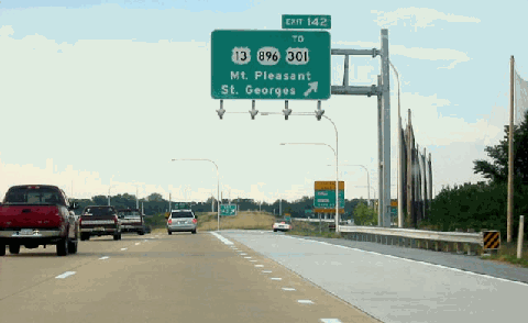
This 2002 photo shows the southbound Korean War Veterans Memorial Highway (DE 1) at EXIT 142 in St. George's. (Photo by Jonathan Lebowitz.)
EARLY STUDIES FOR A NORTH-SOUTH TURNPIKE: Despite the early failures of the Dover Bypass proposals, officials went ahead with more ambitious plans for a north-south turnpike. Beginning in 1970, and continuing throughout much of that decade, state officials proposed a north-south spur of the Delaware Turnpike connecting I-95 with the Dover area.
The state's "Delaware North-South Corridor Study" in 1970 analyzed six alternatives, and like previous studies endorsed a westerly bypass of Dover. A second study conducted by Michael Baker Jr., Incorporated for Kent County recommended that a 34-mile-long freeway be built from Tybouts Corner south, with an easterly bypass of Smyrna and a westerly bypass of Dover. A third study undertaken by DeLeuw, Cather and Associates recommended that a north-south turnpike be built to the west of US 13, and connect I-95 with the Dover area. It was this study that was the genesis of today's "relief route." By the end of the decade, another committee presented Governor Pierre duPont with a fourth study for a controlled-access highway. However, the state did not take any action out of any of these studies.
INTERSTATE REJECTED A SECOND TIME: At the same time, Delaware highway officials, in conjunction with highway officials from Maryland and Virginia, requested Federal highway funds for the construction of an Interstate highway from Wilmington to Norfolk. Such a plan was rejected originally under the 1956 Highway Act, but with the addition of 1,500 miles nationwide under the 1968 Act, the long-awaited Delmarva Interstate came one step closer to reality. However, the U.S. Department of Transportation ultimately rejected the proposal.
This 2002 photo shows the southbound Korean War Veterans Memorial Highway (DE 1) approaching EXIT 104 (US 13) in Dover. (Photo by Jonathan Lebowitz.)
"The goal was not to find a solution that everybody could stand up and cheer for. It's a compromise solution." - John T. Davis, director of Division of Highways, Delaware Department of Transportation (1991)
STARTING OVER FROM SCRATCH: Frustrated by more than two decades of delay and inaction, the Delaware Department of Transportation (DelDOT) swept the slate clean in 1983. It began new studies on a north-south corridor, and hired a new design team. The following year, DelDOT initiated public hearings along the US 13 corridor after state transportation secretary Kermit H. Justice announced to the General Assembly that DelDOT undertake the "Relief Route" project.
From the onset, the proposed highway was designed to solve multiple congestion points along US 13 from Dover north to New Castle County. To the north, DelDOT had devised separate plans to upgrade DE 7 through Christiana as a controlled-access facility. It soon become apparent that the upgrade DE 7 was to be what DelDOT called "the logical connection between I-95 and the Relief Route."
In October 1985, DelDOT published a draft environmental impact statement (DEIS) for the proposed "Relief Route." The statement proposed the following three basic alignments:
Westerly corridor: new alignment west of US 13 Central corridor: reconstruction of existing US 13 as freeway facility with service roads Easterly corridor: new alignment east of US 13; possibly to be routed as far east as DE 9
However, DelDOT did not agree to any definite alignments. Indeed, the new philosophy had become as DelDOT put it, "ask questions first, draw lines later." A number of different groups from farmers and environmentalists to Chambers of Commerce had to be satisfied with the final alignment. Only after a series of often-contentious public hearings over the next 20 months did planning officials draw up a final alignment.
FINALLY, AN AGREED ALIGNMENT: In June 1987, DelDOT released its final environmental impact statement. One month later, the Federal Highway Administration (FHWA) and the U.S. Environmental Protection Agency (EPA) gave location approval to the "Relief Route."
Rather than stick to a single alternative, the final approved alignment was a series of compromises. The northerly six miles - from Christiana south to Tybouts Corner - actually was to be a reconstruction of the existing four-lane-divided DE 7 as a freeway facility. From Tybouts Corner south to Smyrna - a distance of 23 miles - the new turnpike was to crisscross the existing US 13 several times, and even utilize the existing US 13 alignment along a couple of segments. The southernmost 17 miles - from Smyrna south to Dover Air Force Base - was to be built on new alignment just east of the existing US 13.
The "Relief Route" qualified as one of six demonstration projects nationwide where toll revenues and Federal highway funds could be mixed for the first time since the dawn of the Federal-aid highway program in the 1950's. By utilizing both toll and taxpayer sources, toll rates were kept to a minimum (eventually a two-dollar toll for the entire route was established), and the time it took to amortize the bonds was reduced. The FHWA stipulated that tolls had to be removed 15 years after completion of the turnpike (or 2018).
A UNIFIED DESIGNATION: In 1989, DelDOT announced a new designation - DE 1 - for the "Relief Route." The turnpike was to tie into the existing DE 1 leading to the state's beaches.
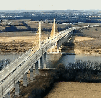
This 1996 photo shows the new Chesapeake and Delaware Canal Bridge in St. Georges. The cable-stayed span carries six lanes of the Korean War Veterans Memorial Highway (DE 1) across the Chesapeake and Delaware Canal. (Photo by Delaware Department of Transportation; supplied by Brian A. Doreste and edited by Scott Kozel.)
DESIGN SPECIFICATIONS: The typical turnpike section was built within a 300-foot-wide right-of-way. The two 40-foot-wide carriageways consisted of two 12-foot-wide lanes, a ten-foot-wide right shoulder and a six-foot-wide left shoulder. Each carriageway was built on an embankment, and separated by a 60-foot-wide landscaped median that permitted construction of a third lane in each direction at a future date.
From the beginning, engineers decided to use concrete instead of traditional asphalt ("hot mix") as the paving surface for the turnpike. They based this decision on the longer average maintenance-free life of concrete pavements (ten or more years, versus three to five years for the average "hot mix" pavement). They also decided to use a 12-inch-thick pavement, rather than the standard 10-inch-thick pavement. Joints were cut every 20 feet (rather than every 40 feet) to more easily allow for pavement expansion. However, engineers did have a use for asphalt: it was used for the shoulders and the pavement's sub-layer.
CONSTRUCTION BEGINS: In July 1987, one month after the Federal government approved the final environmental impact statement, work began on the six-mile-long free segment from EXIT 156 (US 13) in Tybouts Corner north to EXIT 166 (DE 58) in Christiana. This was followed 13 months later by the groundbreaking of the 17-mile-long toll segment from EXIT 95 (US 113) in Dover north to EXIT 119 (US 13) in Smyrna.
The first section of the "Relief Route" opened to traffic in the area of Tybouts Corner in August 1991, followed by a second stretch in that area three months later. The third stretch of the Tybouts Corner-Christiana section between EXIT 162 (DE 273) and EXIT 165 (I-95) was delayed due to construction through a wetlands area. In the interim, DelDOT opted to use the existing DE 7 from EXIT 164 (Mall Road) north to I-95. By December 1993, both the Tybouts Corner-Christiana and Dover-Smyrna segments opened to traffic in their entirety. The Dover-Smyrna section had a one-dollar toll upon opening.
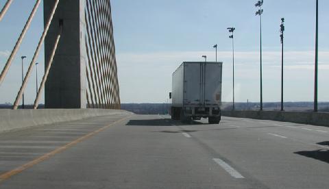
This 2003 photo shows the southbound Korean War Veterans Memorial Highway (DE 1) crossing over the Chesapeake and Delaware Canal Bridge. (Photo by Christopher Mason.)
CROSSING THE C&D CANAL: The DE 1 crossing over the Chesapeake and Delaware (C&D) Canal was built to relieve congestion on the nearby four-lane St. George's Bridge, a four-lane arch span that carried US 13 over the canal. It was to be paid largely with Federal funds, and consequently, tolls could not be charged on the bridge and its immediate approaches.
Engineers decided upon a cable-stay span to carry the turnpike across the canal. The C&D Canal Bridge was built with a main span of 750 feet, and had 145 feet of vertical clearance to permit ships to safely navigate on the canal between the Port of Baltimore and Northeast ports (and beyond). Including approaches, the span measures 4,498 feet from end to end.
A series of diagonal cables were strung from the two towers to the median. On either side of the median are the bridge's two 46-foot-wide roadways, each of which has three 12-foot-wide lanes and a ten-foot-wide right shoulder. The bridge can be re-striped to handle four lanes of traffic on one carriageway when the other carriageway is taken out of service.
After more than three and one-half years of construction, the $99 million C&D Canal Bridge and its approaches opened to traffic on December 21, 1995, several months ahead of schedule. The bridge's completion coincided with that of 6.6 miles of DE 1 (between EXIT 142 and EXIT 148) through the area of St. George's.
When the new span opened, there was serious debate about the future of the existing St. George's Bridge. Built in 1942, the existing bridge needed $30 million in repairs for it to handle four lanes of traffic adequately, and to maintain its structural integrity. DelDOT officials decided to keep the old span opening after determining that average traffic volumes (AADT) across the canal would reach 88,000 vehicles per day, reaching the capacity of the new span. Officials from St. George's, whose town is split in two by the canal, also wanted to keep the old bridge open so that area residents would not have the use an expressway just to drive across the canal.
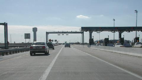
This 2003 photo shows the southbound Korean War Veterans Memorial Highway (DE 1) at the Biddles Corner toll plaza. Two high-speed EZ-Pass express lanes in each direction permit traffic to pass through the plaza at highway speeds. (Photo by Christopher Mason.)
THE "ODESSA BYPASS": In February 1996, DelDOT let out contracts for the 7.2-mile-long "Odessa Bypass" section stretching from EXIT 133 (US 13) in Odessa north to the already-completed section of the DE 1 Turnpike at EXIT 142 (US 13 / DE 896) in St. Georges. The opening of the $78 million section in November 1999 helped alleviate chronic congestion at the US 13 / DE 299 intersection in Odessa, now bypassed at EXIT 136 (DE 299). The newly opened section included the first high-speed EZ-Pass lanes in the EZ-Pass network (charging a one-dollar toll) at the Biddles Corner toll plaza.
MORE WORK AROUND DOVER: Contracts also went out in 1996 for a 1.2-mile-long southerly extension of the DE 1 Turnpike around the area of Dover Air Force Base. As part of the project, the main gate of the base was moved back away from the roadway to accommodate construction of an overpass and connecting ramps at EXIT 93, as well as for construction of a new main gate for visitors. New ramps also were built at EXIT 92 at the southern end of the base. During construction, temporary facilities were built at the northern end of the base to handle all base-bound traffic. The $30 million project was completed in July 2000.
DelDOT also built an improved connection to points southwest via US 13. The 2.3-mile-long, four-lane Puncheon Run Connector, which connects EXIT 97 on DE 1 with US 13, was named after the tributary from the St. John's River that runs along the highway. Built at a cost of $27 million, the connector opened in December 2000 after four years of construction. There is an exit for eastbound connector traffic to Bay Road (former US 113) and DE 1 southbound.
EXTENDING ROUTE 1 NORTH OF I-95: Toward the end of 1996, work proceeded on improving the existing section of DE 1 / DE 7 from EXIT 164 (Mall Road) past I-95, culminating at a new partial-cloverleaf interchange for EXIT 166 (DE 58). Although much of the work was completed by 1999, there remains a missing movement from DE 1 / DE 7 southbound to I-95 southbound. Construction of a direct interchange ramp to complete this movement will not begin until after 2005, while a complete redesign of EXIT 165 (I-95) is not slated to begin until after 2010.
FINISHING ROUTE 1: The last section to be built was the 8.9-mile-long Smyrna-Odessa section between EXIT 119 (US 13) and EXIT 133 (US 13). In the last of many project groundbreakings, DelDOT broke ground for the Smyrna-Odessa section in March 2000. There are no exits along this section. DelDOT also built a new four-lane US 13 alongside the new DE 1 while keeping the old US 13 open. The $82 million section was completed on May 18, 2003. Final connections to the new US 13 were opened two months later.
During the 16 years of construction, workers laid down 1.4 million square feet of concrete pavement, used 1.3 million tons of hot mix, moved more than 30 million cubic yards of soil, used more than 30 million pounds of steel rebar, and installed nearly 40 miles of drainage pipe. In addition to relocating US 13 and other roads, as well as building 21 bridges, DelDOT engineers also created 488 acres of new wetland (to replace the 317 acres that were lost). The total cost of the project was $900 million.
According to DelDOT, the Korean War Veterans Memorial Highway carries approximately 35,000 vehicles per day (AADT) through the Dover area; approximately 45,000 vehicles per day through the St. Georges area; and approximately 65,000 vehicles per day in the Christiana area. The highway has a 65 MPH speed limit for much of its length, except for the 55 MPH sections along the six-mile-long Tybouts Corner-to-Christiana section, the section near Dover Air Force Base, and the Puncheon Run Connector. Exits are numbered in kilometers from the southern terminus of DE 1 at the Delaware-Maryland border in Rehoboth Beach.
CHANGES FOR INTERCHANGES In August 2002, DelDOT converted emergency exit ramps at DE 8 in Dover to public use following a two-month-long project. The new EXIT 99, which was included in the original studies from the 1980's but deleted subsequently, was built to relieve congestion on nearby US 13. To mitigate the impact of the completed interchange, DelDOT purchased development rights along DE 8 (from DE 1 east to DE 9) to curtail further development.
In February 2004, DelDOT approved plans for a $5 million interchange at Summit Bridge Road near Townsend. This interchange also was in original plans, but officials at the time decided to scrap the interchange and focus on development further north. Construction of the interchange is supported by local officials (including fire and emergency personnel), but is opposed by environmentalists. With construction plans squelched in the near-term, DelDOT plans temporary access ramps for use by emergency vehicles at the Townsend site.
Near the northern terminus of the DE 1 Turnpike in Christiana, DelDOT plans a $165 million reconstruction project that will include a new three-lane, high-speed flyover ramp from southbound I-95 to southbound DE 1 / DE 7, as well as a new collector-distributor (C/D) road along northbound DE 1 / DE 7 that will serve northbound I-95 and the nearby Christiana Mall. The project is slated to begin in the spring of 2011, with completion not expected until at least 2015.
AND AT THE DOVER TOLL PLAZA: In May 2003, DelDOT completed a $7.7 million project to retrofit the Dover toll plaza with new high-speed EZ-Pass lanes. Prior to reconstruction, the Dover toll plaza had 12 traditional toll lanes. Motorists had to slow down to 10 MPH at the toll plaza, often creating congestion during peak periods. The new setup provides for three traditional toll lanes and two high-speed EZ-Pass lanes in each direction.
OTHER UPGRADES PLANNED: Only one year after completion of the turnpike, DelDOT turned its attention to a four-mile stretch between EXIT 156 (US 13) and EXIT 162 (DE 273). The concrete is crumbling along this stretch, a problem common on concrete pavements built during the 1970's and 1980's (as was the case with I-495 just a few miles away) after new environmental regulations were passed. The $10 million project, which will require lane closures during peak summer travel periods, was completed in late 2005.
DelDOT has long-term plans to widen the initial section of the four-lane DE 1 Turnpike to six lanes from EXIT 156 (US 13) in Tybouts Corner north to EXIT 165 (I-95) in Christiana. However, DelDOT has not allocated any funds for this project until at least 2013.
HIGHER TOLLS FOR THE WEEKEND: In October 2007, DelDOT increased the weekend cash toll for passenger cars to $2.00 (from $1.00) at the Biddles Corner and Dover toll plazas to pay for more than $300 million in projects on DE 1 and I-95. The weekend tolls apply from 7:00 PM on Friday until 11:00 PM on Sunday; the weekday toll of $1.00 remains unchanged outside this period. DelDOT also eliminated EZ-Pass discounts, but kept the 50-cent toll at the EXIT 104 and EXIT 142 toll plazas and the 25-cent toll at the EXIT 114 toll plaza.
WILL DELAWARE TAKE ROUTE 1 PRIVATE? In the mid-2000's, Governor Ruth Ann Minner and DelDOT suggested public-private partnerships, including leasing the DE 1 Turnpike, Delaware Turnpike (I-95), and proposed US 301 Turnpike to private firms, to address DelDOT's budget shortfalls. Under such an arrangement, the state would receive a lump-sum payment while the private firms would collect tolls and maintain the highways.
During its first full year of operation, the DE 1 Turnpike generated $31 million in toll revenue, but DelDOT expects revenue to jump to $37 million by 2011.
This 2001 photo shows the southbound Korean War Veterans Memorial Highway (DE 1) approaching EXIT 97 (Puncheon Run Connector to US 13). Note the unusual "1/3 mile" advance guide sign on the right as well as the currently non-existent US 113 designation on the left guide sign. (Photo by Cary B. Todd via www.aaroads.com.)
WILL THE TURNPIKE BE EXTENDED SOUTH? With the completion of the DE 1 Turnpike, officials have shifted their focus to improving 31 miles of DE 1 from Dover south to Lewes. These changes could include replacing at-grade intersections with grade-separated interchanges, and building service roads to minimize displacement of homes and businesses. However, there are no current plans to extend DE 1 as a full freeway south to Lewes, nor have there been construction cost estimates and timetables established.
In 1997, an article in Roads and Bridges magazine recommended that a new Interstate highway be built to continue south from Dover to the Hampton Roads area, and possibly beyond:
I-101 Philadelphia to Virginia Beach-Norfolk to Raleigh: This route would provide a bypass of the Richmond to Baltimore I-95 corridor, providing much needed additional capacity to the rapidly growing South, while improving access to the Virginia Beach-Norfolk area, a rapidly growing metropolitan area and major seaport. The route would generally follow the US 13 corridor from Wilmington to Norfolk, using the Chesapeake Bay Bridge-Tunnel, and would continue to connect with I-85 in the Raleigh area. Approximately 350 miles of construction would be required.
WILL THE REAL I-99 PLEASE STAND UP? The American Association of State Highway and Transportation Officials (AASHTO) should consider changing the designation for the Delaware Relief Route, along with a future freeway south along the Delmarva Peninsula to the Chesapeake Bay Bridge-Tunnel, to I-99. In addition to serving local traffic needs on the peninsula and long-distance traffic needs (as an easterly bypass of I-95 between the Northeast and the Hampton Roads area), I-99 fits well within the national highway network, both functionally and numerically. The existing I-99 in west-central Pennsylvania then would receive a new designation: I-170.
SOURCES: "The Road to Relief," The Delaware State News (4/07/1991); "Crossing the Delaware" byMike Britt, W. Denney Pate, and Lou Triandafilou, Public Roads (July 1995); "Interstate 2000: Improvement for the Next Millennium," Roads and Bridges (June 1997); "Last Work on Delaware 1 Nears End" by Patrick Jackson, The Wilmington News-Journal (12/08/2002); "Ribbon Cut on Last Section of Delaware 1" by Drew Vulturo, The Delaware State News (5/19/2003); "The Last Piece in Place," The Wilmington News-Journal (6/16/2003); "On the Road (1989-2003), Delaware Department of Transportation (2003); "State Outlines Delaware 1 Options" by Chip Guy, The Wilmington News-Journal (2/02/2004); "Delaware 1 Interchange Wins an Approval" by Melissa Tyrrell, The Wilmington News-Journal (2/20/2004); "High-Speed EZ Pass To Open in Dover" by Patrick Jackson, The Wilmington News-Journal (5/25/2004); "Key Stretch of Route 1 To Be Shut Down and Rebuilt" by Patrick Jackson, The Wilmington News-Journal (6/19/2004); "Delaware 1 Ramps Near Townsend Rejected" by Patrick Jackson, The Wilmington News-Journal (2/24/2005); "Delaware 1 To Be Concessioned to Investors and Perhaps US 301 Too" by Peter Samuel, Toll Roads News (4/27/2005); "Draft FY 2008-2011 Transportation Improvement Program," Delaware Department of Transportation (2006); "DelDOT Considers Cashing In on Toll Roads" by Summer Harlow, The Wilmington News-Journal (1/07/2007); "Settlement Won't Speed I-95 Plan" by Angie Basiouny, The Wilmington News-Journal (1/11/2007); "Higher Tolls, Fees Start Today," The Wilmington News-Journal (10/01/2007);"JFK Memorial Highway Improvement Program, SR 1 / I-95 Interchange," Delaware Department of Transportation (2010); Scott Kozel; Dan Mengel; Alex Nitzman; Ken Weaverling.
DE 1 shield by Ralph Herman. Lightposts by Millerbernd Manufacturing Company.
KOREAN WAR VETERANS MEMORIAL HIGHWAY ("RELIEF ROUTE") LINKS: