
|
This 2001 photo shows the eastbound NJ 90 Freeway approaching Camden CR 644 in Pennsauken. (Photo by Alex Nitzman.) |
||

|
CONNECTING SOUTH JERSEY TO THE BETSY ROSS BRIDGE: In 1963, the Delaware River Port Authority (DRPA) proposed two new crossings of the Delaware River to alleviate congestion on the Benjamin Franklin and Walt Whitman bridges between Philadelphia and southern New Jersey. The more northerly of the two new crossings, the Betsy Ross (Delair) Bridge, was to connect Pennsauken, New Jersey with the Bridesburg section of Philadelphia. |
||
|
In 1964, the New Jersey State Highway Department announced plans for the NJ 90 Freeway, the designated feeder road for the Betsy Ross Bridge. Three years later, the state agency, now reorganized as the New Jersey Department of Transportation (NJDOT), described the route of the proposed NJ 90 Freeway as follows: |
||
|
CUT SHORT IN CINNAMINSON: In 1984, Governor Thomas Kean approved a shortened extension of the NJ 90 Freeway under the statewide transportation trust fund. When construction began in March 1986, accommodations had to be made for heightened environmental concerns. Five viaducts were built over Pennsauken Creek, the ecologically sensitive home for local waterfowl. The 0.8-mile-long, four-lane eastern extension to NJ 73 in Cinnaminson opened to traffic on October 25, 1988. The NJ 90 extension project cost the NJDOT $23 million, of which $6.5 million was reimbursed by the DRPA. |
||
|
According to the NJDOT, the NJ 90 Freeway carries approximately 45,000 vehicles per day (AADT) at the Betsy Ross Bridge toll plaza, falling to approximately 30,000 vehicles per day east of US 130. The speed limit along the entire length of the NJ 90 Freeway is 45 MPH. |
||
|
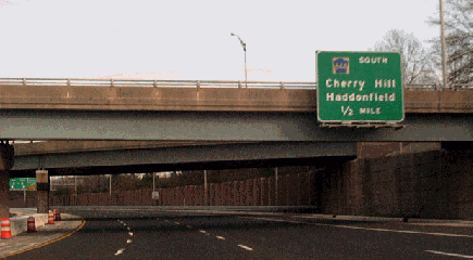
This 2002 photo shows the beginning of the westbound NJ 90 Freeway at NJ 73 in Pennsauken. Plans to extend the NJ 90 Freeway east to the New Jersey Turnpike were thwarted during the 1980's. (Photo by Christopher G. Mason.) |
||

|
EXTENDING TO MOUNT LAUREL: As originally envisioned by the NJDOT, the DRPA and the DVRPC in 1964, the NJ 90 Freeway was to have been an integral part of a two-state freeway network. To the east of the Betsy Ross Bridge, the east-west route was to connect to I-295 and the New Jersey Turnpike, the two principal north-south express routes through southern New Jersey, in the area of Mount Laurel. |
||
|
Highway officials in New Jersey developed the following two alternate routes for the NJ 90 Freeway: |
||
|
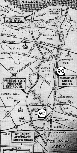
This map shows the rejected "red route," and the adopted (but later abandoned) "green route" for the NJ 90 Freeway. (Map by William Streckfuss from The Philadelphia Inquirer archives.) |
||
|
The Delaware Valley Regional Planning Commission (DVRPC) estimated the cost of the 6.3-mile-long expressway at $42 million. Completion of the freeway had been scheduled for 1975. |
||


|
IMPROVED ACCESS TO PHILADELPHIA: To further improve access from South Jersey to Philadelphia and alleviate congestion on existing crossings, the NJ 90 Freeway should be extended east to I-295 and the New Jersey Turnpike. As an integral part of the interstate highway network, the extended NJ 90 Freeway should be re-designated I-695. |
||

|
SOURCES: "New Delair Bridge Site OK'd by Three Camden Lawmakers," The Philadelphia Inquirer (12/05/1964); "Realignment of Route 90 at Mount Laurel Asked" by Francis M. Lordan, The Philadelphia Inquirer (10/31/1966); "Philadelphia's Comprehensive Plan for Expressways," Philadelphia City Planning Commission (1966); New Jersey Highway Facts, New Jersey Department of Transportation (1967); 1985 Regional Transportation Plan, Delaware Valley Regional Planning Commission (1969); "Report on the Status of the Federal-Aid Highway Program," Committee on Public Works, U.S. Senate (1970); Mass Transportation Development Program, Delaware River Port Authority and Urban Mass Transportation Administration (1975); "Route 90 Set To Open This Week" by Dianne Gordon-Lyle, The Philadelphia Inquirer (10/23/1988); Raymond C. Martin; Dan Moraseski; Scott Oglesby; Brian Polidoro; Len Pundt; Jeff Taylor. |
||

|
NJ 90 FREEWAY LINKS: |
||
|
NJ 90 FREEWAY CURRENT CONDITIONS: |
||

|
OFF-SITE EXIT LISTINGS: |
||
|
VIEW OR SUBMIT YOUR RATINGS TO RATETHEROADS.COM: |
||

|
|
||

|
Back to The Roads of Metro Philadelphia home page. |
||
|
Site contents © by Eastern Roads. This is not an official site run by a government agency. Recommendations provided on this site are strictly those of the author and contributors, not of any government or corporate entity. |
||