
|
|
||
|
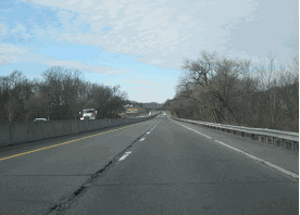
This 2010 photo shows the northbound PA 33 Expressway approaching the unsigned EXIT 4 (US 22 / Lehigh Valley Thruway) in Palmer Township. (Photo by Steve Anderson.) |
||
|
Length: |
||
|
27.7 miles (44.6 kilometers); mainline |
||

|
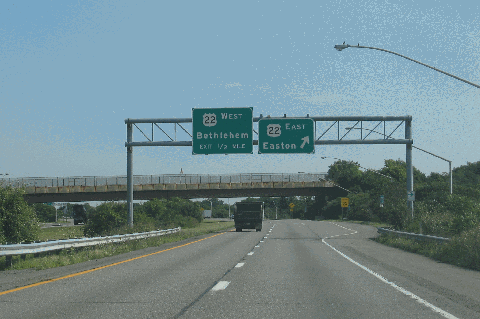
CONNECTING THE LEHIGH VALLEY WITH THE POCONOS: Plans for the PA 33 Expressway were first announced in 1956 when the Pennsylvania Department of Highways (PDH) proposed a bypass of US 611 (now PA 611) from Bethlehem north to Bartonsville. The four-lane, north-south route was designed to connect US 22 (Lehigh Valley Thruway)--which at the time was proposed to be part of I-78--with I-80. It also was to serve as a bypass for trucks unable to use the Lehigh Tunnel on the Pennsylvania Turnpike-Northeast Extension (I-476). |
||
|
The first section to open was a 5.0-mile-long stretch from PA 512 in Wind Gap north to Saylorsburg. Built from 1959 to 1960, and originally designated as PA 90, the freeway was not built to Interstate highway standards despite having full control of access. A narrow median, limited sight distances, steep grades of up to 6%, and short acceleration-deceleration lanes characterized this section. The PA 90 designation lasted only one year, and beginning in 1961, the freeway was known as PA 115. |
||


|
In 1964, a second section of freeway stretching 8.1 miles opened from Saylorsburg north to its northern terminus at PA 611 in Bartonsville. This section was similar in design to the initial section as it also was built to sub-Interstate highway standards despite offering full control of access. Including in this section was a partial interchange with I-80, as well as a four-lane US 209 spur that connected the PA 115 Freeway with I-80 in Stroudsburg. The US 209 spur offered partial control of access, though there is--and remains--a traffic light at Shafers School House Road in Stroud Township. |
||
|
The next section of the PA 115 Freeway to open was a 5.8-mile-long segment from PA 512 in Wind Gap south to PA 191 in Stockerton. Built between 1967 and 1969, this section was closer in design to contemporary Interstate highway standards, featuring a wide median strip and longer acceleration-deceleration lanes. |
||
|
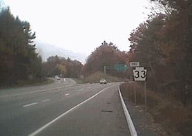
LEFT: This 2018 photo shows the southbound PA 33 Expressway just south of the unsigned EXIT 24 (Snydersville / Manor Drive) in Hamilton Township. (Photo by Steve Anderson.) RIGHT: This 2005 photo shows the northbound PA 33 Expressway approaching the unsigned EXIT 27 (I-80) in Stroudsburg. The expressway ends just north of the PA 33 / I-80 interchange at PA 611 in Stroudsburg. (Photo by Doug Kerr.) |
||
|
EXTENDING SOUTH TO A RELOCATED I-78: For many years, the future of the PA 33 extension seemed uncertainty, particularly as the future of its connecting route to the south, I-78, also was uncertain. After a moratorium on statewide highway construction, PennDOT approved the 3.3-mile-long extension, which included a new high-level bridge across the Lehigh River, in 1983. |
||
|
Even as state officials pressed for the construction of PA 33, the cost of the extension climbed from $52 million in 1986 to $78 million by 1989, and in 1990, when the state said it would delay construction until the late 1990s, the estimated cost of the extension had risen to $100 million. US Senator John Heinz and US Representative Don Ritter pushed for the Federal government to reimburse the state for half of the construction cost. |
||
|
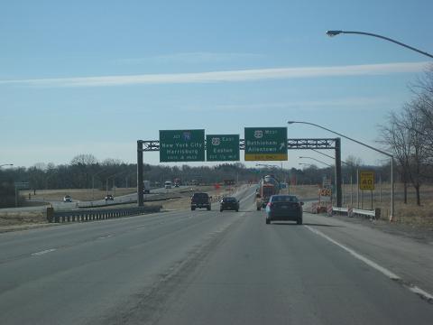
This 2010 photo shows the southbound PA 33 Expressway approaching the unsigned EXIT 4 (US 22 / Lehigh Valley Thruway) in Palmer Township. (Photo by Steve Anderson.) |
||

|
EXTENDING SOUTH TO DOYLESTOWN AND PHILADELPHIA? Beginning in the late 1950s, the Philadelphia Urban Traffic and Transportation Board, a predecessor agency to Delaware Valley Regional Planning Commission (DVRPC), proposed extending Woodhaven Road (PA 63), a controlled-access freeway, north into Bucks County and beyond as a "611 Relief Route" expressway. Continuing through the 1960s, the DVRPC and other highway planners had the following two-stage proposal for extending Woodhaven Road beyond Lower Moreland Township: |
||
|
|
||
|
In 1964, the Comprehensive Plan for Lehigh and Northampton Counties concurred with planning officials in the Delaware Valley and developed their own plan for the 611 Relief Route, which it called the "North-South Expressway." The Doylestown Bypass, which was built in the mid-1970s, survives as part of this original plan. |
||

|
The scope of the North-South Expressway was reduced in 1967 when the southern terminus of the expressway was moved north to Harrow (Nockamixon Township) in Bucks County. The relocation of the I-78 alignment south of the urbanized Allentown-Bethlehem-Easton area in 1969-1970 necessitated a new interchange between I-78 and PA 33. However, these new plans did not include an extension of PA 33 south of I-78, effectively killing the North-South Expressway / 611 Relief Route. |
||
|
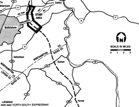
This map from the 1993 final environmental impact statement for the PA 33 extension shows the originally proposed "611 Relief Route" extending south through Northampton and Bucks Counties. (Map created by Clarke & Raupano; report developed by Pennsylvania Department of Transportation.) |
||

|
PennDOT should adopt a milepost-based exit numbering scheme on the PA 33 Expressway as follows: |
||


|
SOURCES: "Loop Highways To Cut Tie-Ups Urged for Area" by James P. McFadden, The Philadelphia Inquirer (12/22/1957); "Route 33 Extension, Route 22 Interchange to Route 78 Interchange, Final Environmental Impact Statement," US Department of Transportation and Pennsylvania Department of Transportation (1993); "Long Journey for Route 33" by Dianne Knauss, The Morning Call (3/04/2001); "Completion of Route 33 Interchange Pushed Back to June" by Bill Landauer, The Morning Call (1/08/2015); "Route 33 Bridges Over Route 22 Set for Rapid Replacement" by Kurt Bresswein, The Express-Times (12/03/2016); Construction Equipment Guide; Charles Chrin Companies; Jeff Kitsko. |
||
|
PA 33 EXPRESSWAY LINKS: |
||
|
PA 33 EXPRESSWAY CURRENT TRAFFIC CONDITIONS: |
||
|
PA 33 EXPRESSWAY VIDEO LINK: |
||
|
THE EXITS OF METRO PHILADELPHIA: |
||

|
Back to The Roads of Metro Philadelphia home page. |
||
|
Site contents © by Eastern Roads. This is not an official site run by a government agency. Recommendations provided on this site are strictly those of the author and contributors, not of any government or corporate entity. |
||