
|
|
||
|
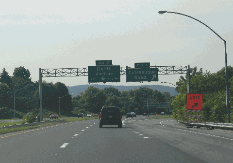
This 2010 photo shows the southbound Bethlehem Spur Route (PA 378) at EXIT 1 (Catasauqua Road) in Bethlehem. At the time of this photo, the original lightpoles and sign gantries from the freeway's opening in 1967 were still standing, though the original sign for EXIT 1 read "Schoenersville Road." (Photo by Steve Anderson.) |
||
|
Length: |
||
|
3.3 miles (5.3 kilometers) |
||

|
AN INTERSTATE SPUR FOR BETHLEHEM: Plans for the Bethlehem Spur Route actually predated the Interstate highway system. First announced in 1954 by the Pennsylvania Department of Highways (PDH), the Bethlehem Spur Route was proposed to link the Lehigh Valley Thruway (US 22), which at the time was nearing completion through the area, with the Hill-to-Hill Bridge across the Lehigh River in Bethlehem. |
||
|
The basic routing for what eventually was designated I-378 was depicted in the 1955 "Yellow Book," which published by the Federal Bureau of Public Roads (BPR), and was shown as a spur extending south from US 22, which originally was planned to carry the I-78 designation through the Lehigh Valley. The freeway was designed to provide quick access from US 22 to the Bethlehem Steel plant on the south side of the Lehigh River. Like the companion Allentown Spur Route (I-178) to the west, the Bethlehem Spur Route was to be built with four lanes, two in each direction. Unlike the Allentown Spur, however, the Bethlehem Spur had much broader support, particularly as most of the route did not go through a dense urban area, nor did it require construction of a new river span. These two factors ultimately killed I-178. |
||
|
Construction of the 3.3-mile-long route began in 1965, when workers moved a Revolutionary War-era burial ground and cabin that stood in the I-378 right-of-way. The remains were moved to a small memorial park on First Avenue, while the cabin was moved to the Rose Garden on Eighth Avenue. Construction of the I-378 bridges began in the spring of 1966. |
||
|
At the Hill-to-Hill Bridge, which was built in 1924 and formed the northern terminus of I-378, the existing two-way bridge approaches that led to Second Avenue to the west, and Main Street to the east, were reconfigured into one-way ramps such that the Second Avenue approach became a southbound-only ramp to the bridge, and the Main Street approach became a northbound-only ramp from the bridge. Another ramp that led southeast from the bridge to Lehigh Street was eliminated. |
||
|
The $7 million Bethlehem Spur Route was opened to traffic on November 20, 1967. The entire length of the route from US 22 south to the Hill-to-Hill Bridge was signed as I-378. |
||

|
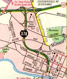
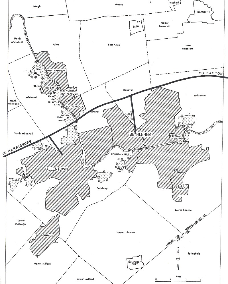
This 1968 map from the Pennsylvania Department of Highways (PDH) shows the completed Bethlehem Spur Route as I-378. The freeway was re-designated PA 378 in 1971, one year after I-78 was officially relocated south of the urbanized Allentown-Bethlehem-Easton area. |
||
|
STILL A FREEWAY SPUR, BUT NO LONGER AN INTERSTATE: After three years of study, the PDH formally agreed to relocate the proposed route of I-78 south of the immediate Allentown-Bethlehem-Easton area in 1969, and in 1970, the Federal government approved the relocation of I-78 from the Lehigh Valley Thruway. With the relocation of I-78 from the US 22 corridor, the completed Bethlehem Spur Route no longer had a direct Interstate highway connection, and the route no longer was eligible for Interstate status. The Pennsylvania Department of Transportation (PennDOT), the successor agency to the PDH, re-redesignated the spur route as PA 378 in 1971. In 1974, the PA 378 designation replaced the PA 191 designation from downtown Bethlehem south to PA 309 in Center Valley. |
||
|
Few changes have been made to the freeway since it opened, as a late 1970s plan to build additional ramps at EXIT 1 (Catasauqua Road) was shelved. However, on the Hill-to-Hill Bridge and the immediate approaches, the ramp from Second Avenue to the southbound bridge was closed in 1973, though the elevated approach remains as a dead-end street despite calls to remove that ramp. In 1988, the ramp from the northbound lanes to River Street and Sand Island Park was removed. In 2011, the southern approach to the Hill-to-Hill Bridge was rebuilt following a two-year project that reconfigured and widened the Wyandotte Street and Second Street ramps to the bridge. |
||
|
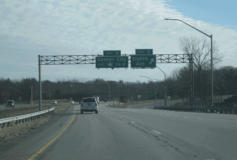
This 2018 photo shows the southbound Bethlehem Spur Route (PA 378) at EXIT 2 (Eighth Avenue) in Bethlehem. PennDOT and city officials devised plans to limit new lighting to the area near interchanges. (Photo by Steve Anderson.) |
||

|
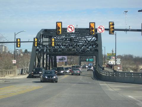
This 2018 photo shows PA 378 looking north from the Brighton Street intersection at the approach to the Hill-to-Hill Bridge. The proposed extension of the Bethlehem Spur Route / South Side Spur would have required construction of a replacement Hill-to-Hill Bridge so that it would comply with Interstate standards. (Photo by Steve Anderson.) |
||
|
A NEW FREEWAY LINK TO A RELOCATED I-78: In 1970, PennDOT submitted a request to the Federal Highway Administration (FHWA) to include a 4.0-mile-long extension of I-378 to connect the Hill-to-Hill Bridge south to the relocated I-78, thereby creating a 7.3-mile-long freeway from US 22 south to the then-proposed I-78. The FHWA denied PennDOT's request. |
||
|
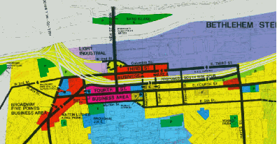
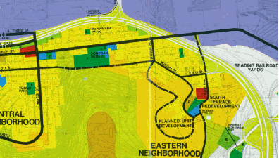
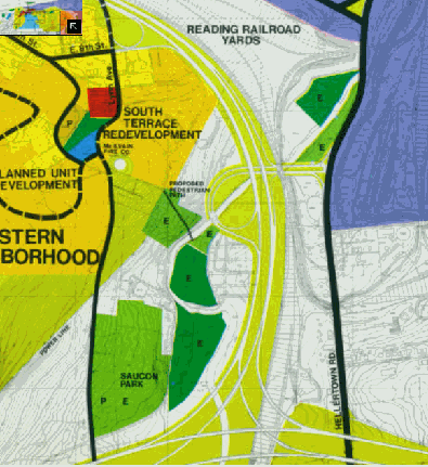
In 1972, city and state officials commissioned Gruen Associates, a leading planning firm, to devise a wide-ranging proposal to develop Bethlehem on the south side of the Lehigh River. A key part of the proposal was the construction of the "South Side Spur," which was a revived plan to extend the Bethlehem Spur Route southeast toward a relocated I-78. The $48 million extension, which PennDOT may have considered for resubmission to the Federal government as an Interstate highway eligible for 90% Federal reimbursement--thus reinstating the I-378 designation--was to have been built as follows: |
||
|
These maps are from the "South Side '72" plan developed by planning firm Gruen Associates. |
||

|
SOURCES: "Spur Route Cloverleafs, Pupil Walkway at Nitschmann Get Bethlehem Backing," The Morning Call (12/17/1963); "Catasauqua Road, 14th Avenue Spans First To Be Worked on Spur Route," The Morning Call (3/17/1966); "Packard Built in 1889 Opens New Spur Route," The (Lehigh University) Brown and White (11/21/1967); South Side '76 Plan Bethlehem, Gruen Associates (1972); "New Minsi Trail Bridge," The Morning Call (11/26/1984); "More Work Sought on Hill-to-Hill Bridge," The Morning Call (3/20/1985); "For Many of Revolution's Wounded and Dying Soldiers, Bethlehem Was Last Stop" by Frank Whelan, The Morning Call (2/10/1991); "History's Headlines: Bethlehem's Hill-to-Hill Bridge," WFMZ-TV (9/25/2015); "Lights Out on Route 378 in Bethlehem: Has Anyone Noticed?" by Sara K. Satullo, The Express-Times (2/27/2017); Lehigh University; Steve Alpert; Jeff Kitsko; Alex Nitzman; Scott Oglesby. |
||

|
BETHLEHEM SPUR ROUTE LINKS: |
||
|
BETHLEHEM SPUR ROUTE CURRENT TRAFFIC MAPS: |
||
|
BETHLEHEM SPUR ROUTE VIDEO LINK: |
||

|
THE EXITS OF METRO PHILADELPHIA: |
||

|
Back to The Roads of Metro Philadelphia home page. |
||
|
Site contents © by Eastern Roads. This is not an official site run by a government agency. Recommendations provided on this site are strictly those of the author and contributors, not of any government or corporate entity. |
||