 |
|
|
|
|
|
|
|
|
|
|
|
|
|
|
|
|
|
|
|
|
|
|
|
|
|
|
|
|
|
|
|
|
|
|
|
|
|
|
|
|
|
|
|
|
|
|
|
|
|
|
|
|
|
|
|
|
|
|
|
|
|
|
 |
|
|
|
 |
|
|
|
|
|
EARLY PLANS FOR A TACONY CREEK PARKWAY: In 1932, the Regional Planning Federation (the predecessor agency to the Delaware Valley Regional Planning Commission) proposed a parkway system around the Philadelphia area similar to that constructed by Robert Moses. Like the Moses parkways in New York, the four-lane parkways were to feature controlled access, stone-arch bridges, timber lightposts and natural vegetation.
|
|
|
|
|
|
 |
|
|
|
|
|
|
|
|
|
|
|
|
|
|
|
|
 |
|
|
|
|
|
|
|
|
|
|
|
|
|
|
|
|
|
|
|
|
|
The 1932 proposal called for a four-lane parkway to be constructed along Tacony Creek. However, without a "power broker" like Moses to coordinate efforts, the parkway system never came to fruition.
THE TACONY EXPRESSWAY: As early as 1947, the Philadelphia City Planning Commission recommended the construction of a "Tacony Expressway" through the Near Northeast section of Philadelphia. Subsequent proposals by the Philadelphia Urban Traffic and Transportation Board, a predecessor agency to the Delaware Valley Regional Planning Commission (DVRPC), had the expressway veering northwest into Montgomery County to join the Fort Washington Expressway (PA 309).
The first serious engineering proposal came in 1958, when the Philadelphia Streets Department and the Pennsylvania Department of Highways mapped a route beginning the Delaware Expressway (I-95), running along Tacony Creek through the community of Bridesburg, Tacony Creek Park and Juniata Golf Course, and ending at the Roosevelt Boulevard-Northeast Expressway combination (US 1).
The expressway contracts were divided into three sections as follows:
SECTION 1: Philadelphia city line (at PA 309) to Roosevelt Boulevard (US 1), along Tacony Creek
SECTION 2: Roosevelt Boulevard (US 1) to Wingohocking Street / Wyoming Avenue, through Tacony Creek Park and a mixed residential-industrial area
SECTION 3: Wingohocking Street / Wyoming Avenue to the Delaware Expressway (I-95)
CONNECTING THE BETSY ROSS BRIDGE TO THE NORTHEAST: The Tacony Expressway plan received a boost in 1963 when the Delaware River Port Authority (DRPA) proposed a new "Delair Bridge" (eventually built as the Betsy Ross Bridge) between the Port Richmond section of Philadelphia and Pennsauken, New Jersey. As part of the approach route for the bridge, the Tacony Expressway was to provide connections to the Delaware Expressway and Roosevelt Boulevard. North of Roosevelt Boulevard, the Tacony Expressway was to be routed along Tacony Creek (through Tacony Creek Park) to the Philadelphia city line.
In 1966, the Philadelphia City Planning Commission included the Tacony Expressway as part of its comprehensive expressway plan. The 1966 proposal was identical to the 1958 plan, except that for section 2, the expressway was to carve through a residential and light industrial area along Adams Avenue, instead of utilizing a route through Tacony Creek Park as in the earlier plan. Completion of the six-mile-long, $59 million expressway was originally scheduled for 1971. Combined with the Roosevelt Expressway and the Betsy Ross Bridge, the Tacony Expressway - which was renamed the Pulaski Expressway in 1969 - was to form part of a "Five-Mile Loop" connecting radial routes to and from Center City.
Two years later, amid outcry from residents along Adams Avenue, the Philadelphia City Planning Commission and the Pennsylvania Department of Highways selected a "compromise route" that took a section of Tacony Creek Park near Roosevelt Boulevard, but avoided Juniata Golf Course and the Adams Avenue area.
|
|
|
|
|
|
 |
|
|
|
|
|
|
|
|
|
|
|
|
|
|
Beginning in 1971, the Pennsylvania Department of Transportation (PennDOT), complying with recently enacted legislation protecting parklands and requiring public notice, devised six different alternative alignments for section 2 as follows:
ALTERNATIVE 2-A: Adams Avenue alignment, avoiding Oakland and Greenwood cemeteries
ALTERNATIVE 2-B: Adams Avenue alignment, cutting through the cemeteries
ALTERNATIVE 2-C: alignment along the western perimeter of the cemeteries, arcing back to the property line between Oakland Cemetery and Friends Hospital
ALTERNATIVE 2-D: alignment through Tacony Creek Park to Roosevelt Boulevard, avoiding Juniata Golf Course, Friends Hospital and the cemeteries
ALTERNATIVE 2-E: Reading Railroad spur, east of the Adams Avenue alignment
ALTERNATIVE 2-F: new alignment between alignment "A" and alignment "E," cutting through Simpson Memorial Park
Under the 1971 plans, section 3 - the section from the park south to the Betsy Ross Bridge approach - remained unchanged. The section north of Roosevelt Boulevard - section 1 - had been dropped from the proposal, but an "Oxford Spur" north to the Oxford Avenue-Levick Street area remained open to study. Unofficial maps published at the time showed the Pulaski Expressway with the PA 90 designation, continuing the route's NJ 90 designation from New Jersey, but official maps showed no such designation. Official planning reports referred to the route as "LR 1078."
DESIGN CHARACTERISTICS: Throughout the entire route, the Pulaski Expressway was to feature 12-foot-wide lanes, 10-foot-wide inner and outer shoulders, a concrete ("Jersey") median barrier, and a 60 MPH design speed. The two remaining sections - section 2 and section 3 - were to be designed as follows:
|
|
|
|
|
|
|
 |
|
|
|
|
|
|
|
|
|
|
|
|
|
|
|
|
|
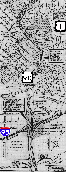
This 1971 map shows the route of the proposed Pulaski Expressway along Tacony Creek. (Map by David Milne from The Philadelphia Inquirer archives.)
|
|
|
|
|
|
|
|
|
|
|
|
|
|
|
|
SECTION 2 (Roosevelt Boulevard / US 1 to Wingohocking Street / Wyoming Avenue): Beginning at the Roosevelt Boulevard trumpet interchange (near the former Sears distribution center), the expressway was to traverse a residential and park area through a depressed section. Between the concrete retaining walls, there was to be six travel lanes (three in each direction). Moving east into an industrial area, the expressway was to transition from an open-cut section to an embankment section. At the four-ramp interchange for Wingohocking Street / Wyoming Avenue, the expressway was to pick up an additional travel lane in each direction.
|
|
|
|
|
|
|
|
|
|
|
|
|
|
|
|
|
|
|
|
|
SECTION 3 (Wingohocking Street / Wyoming Avenue to Delaware Expressway / I-95): Beginning at the Wingohocking Street / Wyoming Avenue interchange, the eight-lane expressway was to transition to a viaduct section, and was to continue as a viaduct for the remainder of this section. Two slip ramps (eastbound exit, westbound entrance) were to connect to Aramingo Avenue. After connecting to the Delaware Expressway at the (already constructed) stack interchange, the expressway was to continue onto the Betsy Ross Bridge.
Cost estimates for the Pulaski Expressway, whose length ranged from 2.6 miles to 3.5 miles (depending on the alignment chosen), ranged from $125 million to $150 million. Following the environmental impact study process, construction was scheduled to begin in 1978, and completion was scheduled for 1981.
|
|
|
|
|
|
|
|
|
 |
|
|
|
|
|
 |
|
|
|
|
|
|
|
|
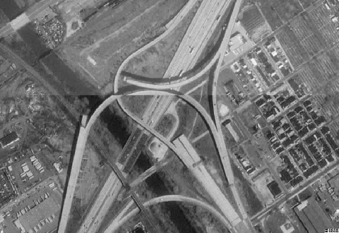
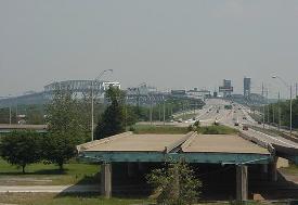
This USGS-Terraserver image shows the interchange between the Delaware Expressway (I-95) and the Betsy Ross Bridge approach. The unfinished ramps were to continue west to the Pulaski Expressway (PA 90). (Terraserver image provided by Alex Nitzman.)
|
|
|
|
|
|
|
|
|
|
|
|
|
|
|
|
|
|
|
 |
|
|
|
|
|
|
|
|
|
|
TURMOIL ALONG TACONY CREEK: The Pulaski Expressway received strong support from residents of Bridesburg and Port Richmond, the areas in the immediate vicinity of the Betsy Ross Bridge. They hoped that the expressway would keep bridge-bound traffic off local streets. However, opposition surfaced among residents of Northwood, Summerdale and other more affluent neighborhoods farther west, who feared losing their houses and to construction. Despite predictions by Mayor Frank Rizzo of "traffic strangulation and chaos" for I-95 and the streets of lower Northeast Philadelphia without the Pulaski Expressway, opposition remained strong.
|
|
|
|
|
|
|
|
|
|
|
|
|
|
To construct the interchange between the Northeast Expressway and the Pulaski Expressway, PennDOT acquired 100 properties between 1970 and 1974 along Roosevelt Boulevard and Adams Avenue in the area just east of Tacony Creek Park.
When the first two houses were demolished in 1975, a local group, "United Communities Against the Pulaski Expressway," erected a granite monument on the site of the two houses. The epitaph read as follows:
We the people of the United Communities Against the Pulaski Expressway, in memory of the two houses that stood here, dedicate this memorial to Governor Milton Sharp for his lack of integrity, PennDOT for destroying a city, and Secretary of Transportation Jacob Kassab for his arrogance.
PennDOT promptly replied in The Philadelphia Evening Bulletin as follows:
Using a memorial to mourn the loss of two homes; to vilify the governor, the secretary of transportation and PennDOT; and to attract attention to a cause was creative, but not entirely accurate
Neither the governor, nor the secretary nor PennDOT have made a decision for or against the Pulaski Expressway. However, as governor officials, they must explore the need for the freeway as a link in the regional highway network that serves the greatest number of people.
Many of the affected homeowners moved out, and 29 homes were eventually demolished. However, PennDOT rented out some of the remaining homes as late as the early 1980's. With PennDOT retaining title to the homes, and homeowners unable to sell to anyone but PennDOT, the area declined for years.
When the Betsy Ross Bridge finally opened in 1976, partially completed ramps leading west from the bridge and I-95 hinted that the Pulaski Expressway might one day be constructed. Indeed, PennDOT, the Federal Highway Administration (FHWA) and the DVRPC carried out a series of traffic and environmental impact studies throughout 1975 and 1976. However, the highway remained entangled in legal, environmental and fiscal difficulties. Specifically, the U.S. Environmental Protection Agency (EPA) determined that carbon monoxide levels in the area, already higher than those set by existing air quality standards, would be increased if the expressway were built.
PULASKI CANCELED: On July 1, 1977, PennDOT halted all funding for proposed highway projects. While this move killed most expressway proposals in Philadelphia area, it did not kill the Pulaski Expressway, which was still under environmental review. Although PennDOT did not officially kill the Pulaski Expressway - it insisted that the road was still being studied - an end to the road appeared in sight in 1980 when the Philadelphia City Highway Department commissioned transportation studies of the area.
Joseph R. Syrnick, chief of the department's expressway unit, said of the Pulaski and Northeast expressways as follows:
The Pulaski Expressway is off the plans and out of the picture completely. And the Northeast Expressway is absolutely dead. It could not be revived.
The Philadelphia City Planning Commission subsequently removed the Pulaski Expressway from the future capital program. Finally, state legislators from Philadelphia were so convinced that the two expressways were dead that they passed Act 100, which specifically provided that PennDOT could sell off properties no longer needed for expressway projects in the city.
From the beginning, the Pulaski Expressway ran into opposition from residents and conservationists, who feared adverse impacts to the community and nearby Tacony Creek Park. Ultimately, PennDOT did not have enough money for the project: the Pulaski Expressway has not appeared in long-term plans since 1980.
|
|
|
|
|
|
|
|
|
|
|
|
|
|
|
 |
|
|
|
|
|
|
|
|
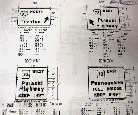
Perhaps the Pulaski Expressway, or the "Pulaski Highway" as shown in these early 1970s sign plans for the I-95 / Betsy Ross Bridge interchange, was to be a relocated PA 73 after all. However, the name of the Betsy Ross Bridge had yet to be legislated by the time these sign plans were created. Across the Delaware River in New Jersey, the connecting freeway received its NJ 90 route designation in 1967. (Photo submitted by "route_82" in the AARoads.com forum.)
|
|
|
|
|
|
|
|
|
|
|
|
|
|
|
|
|
|
|
|
NEW RAMPS WHERE THE PULASKI WAS TO RUN: For nearly a generation, Bridesburg residents lived at an uneasy peace with the Betsy Ross Bridge, as trucks to and from the bridge rumbled through Richmond Street and other area streets. To address this problem, the DRPA, PennDOT and the Philadelphia City Council reached agreement on a solution that would take trucks away from residential streets.
|
|
|
|
|
|
|
|
|
|
|
|
|
|
The new ramps connected Delaware Expressway (I-95) with a newly revitalized commercial area along Aramingo Avenue, which parallels I-95 through the area. After a decade of traffic and environmental studies, work began on the new ramps in 1997. The I-95 / Aramingo Avenue interchange, which was built and paid for by PennDOT, was completed in 1999. The project extended the "ramps-to-nowhere" at EXIT 26, which originally were intended for the Pulaski Expressway (PA 90), to Aramingo Avenue.
Even after this project ended, officials still tried to extend the Betsy Ross Bridge approach past the elevated stub, which had been in place about 100 yards east of I-95 since the 1970s. In 2003, the DRPA conducted a traffic study of the area, estimating that a direct connection between the Betsy Ross Bridge and Arimingo Avenue would attract about 20,000 vehicles per day, while a proposed extension along an expanded Adams Avenue north to Torresdale Avenue would attract about 10,000 vehicles per day.
In 2015, PennDOT announced a $160 million project to improve access between the Betsy Ross Bridge, I-95, Aramingo Avenue, and Torresdale Avenue. The project entails the following improvements:
Extending the Betsy Ross Bridge main approach roadway over I-95 west to the existing connection for Aramingo Avenue.
Widening the bridge on the ramp from northbound I-95 to Aramingo Avenue.
Widening and replacing the bridge deck on the ramp from Aramingo Avenue to southbound I-95.
Relocating and replacing the ramp from southbound I-95 to the Betsy Ross Bridge.
Rehabilitating the bridge on the ramp from southbound I-95 to Aramingo Avenue.
Building a new connection from Aramingo Avenue to Torresdale Avenue over a rehabilitated and expanded Adams Street.
Building new ramps connecting Adams Street with the Betsy Ross Bridge and I-95. (Traffic from the westbound Betsy Ross Bridge and I-95 would have to use Aramingo Avenue to connect to Adams Street and Torresdale Avenue.)
Removing the abandoned Thompson Street bridge over Frankford Creek.
Relocating gas and sewer mains.
Construction on the project, which is part of the much larger "95 Revive" project, began in March 2015, and is scheduled for completion in late 2020. Nearby work along I-95, which includes widening the main roadway to four lanes (from three) in each direction and rebuilding ramps, is expected to continue through 2023.
|
|
|
|
|
|
|
|
|
|
|
|
|
|
 |
|
 |
|
|
|
|
|
|
|
|
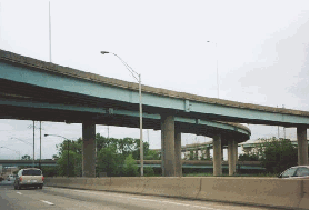
LEFT: In the years since the Terraserver image was taken, the unfinished ramps at the I-95 / Betsy Ross Bridge interchange have been completed. However, the ramps now lead to the Aramingo Avenue Connector. (Photo by Alex Nitzman.) RIGHT: However, the mainline roadway of the Betsy Ross Bridge still ends in mid-air as depicted in this 2000 photo, though work to extend this mainline bridge over I-95 is expected to be completed by late 2020. (Photo by Jim K. Georges.)
|
|
|
|
|
|
|
|
|
|
|
|
|
|
 |
|
|
|
|
|
The Pulaski Expressway should be reconsidered as a proposed route to connect Roosevelt Boulevard (which may be upgraded to a controlled-access freeway) with the Betsy Ross Bridge. Much of the right-of-way for section 3 already has been acquired, and part of the right-of-way is being used for the Aramingo Avenue-Torresdale Avenue Connector. For section 2, alternative 2-C should be used, minimizing disruption to nearby communities and parkland.
|
|
|
|
|
|
|
|
|
|
|
|
|
|
Beginning at the extended Roosevelt Expressway, where a trumpet interchange would be constructed, the Pulaski Expressway would be depressed relative to street level near residential areas and parkland. The six-lane expressway would transition slowly to embankment and viaduct segments through the commercial and industrial areas of Bridesburg.
|
|
|
|
|
|
|
|
|
|
|
|
|
|
|
|
|
|
|
 |
|
|
|
 |
|
|
|
|
|
SOURCES: Regional Plan of the Philadelphia Tri-State District, Regional Planning Federation (1932); "Philadelphia Expressway System," Philadelphia City Planning Commission (1947); "Schuylkill Expressway, Roosevelt Boulevard Expressway and Vine Street Expressway," Philadelphia City Planning Commission (1950); "Loop Highways To Cut Tie-Ups Urged for Area" by James P. McFadden, The Philadelphia Inquirer (12/22/1957); "New Delair Bridge Site OK'd by Three Camden Lawmakers," The Philadelphia Inquirer (12/05/1964); "Philadelphia's Comprehensive Plan for Expressways," Philadelphia City Planning Commission (1966); 1985 Regional Transportation Plan, Delaware Valley Regional Planning Commission (1969); "State Urged To Speed Up Work on Pulaski Route" by Robert Fensterer, The Philadelphia Inquirer (12/20/1970); "Work Begins on Access Ramps for Bridesburg-Delair Bridge" by Robert Fensterer, The Philadelphia Inquirer (4/25/1971); "50 Mourn Loss of Two Houses" by J. Harry Camp, The Philadelphia Evening Bulletin (9/24/1975); "Delaware Bridge Opens May 1," The New York Times (3/20/1976); "Highway Under Cloud of Bad Air" by Carol Towarnicky, Philadelphia Daily News (7/22/1976); "Pulaski Expressway: Draft Environmental Impact Statement and Section 4(f) Statement," Pennsylvania Department of Transportation and Federal Highway Administration (1976); "The Bridge to Nowhere" by Robert McG. Thomas, Jr., The New York Times (3/06/1977); "Eleven Years in Bureaucratic Limbo" by Russell Cooke, The Philadelphia Inquirer (4/09/1981); Capital Program: City of Philadelphia, Philadelphia City Planning Commission (1981); "In Search of a Better Way On and Off the Betsy Ross," The Philadelphia Inquirer (6/18/1983); "Schuylkill Carries the Load of Many Roads Left Unbuilt" by Paul Nussbaum, The Philadelphia Inquirer (8/19/1984); "Neighborhoods Hope Ramps Lead to Peace" by Maria Panaritis, The Philadelphia Inquirer (8/30/1998); "Don't Be Steered Wrong: Ramps from Betsy Ross Bridge to Aramingo Avenue Not Yet Open" by Mike DeNardo, KYW-AM (12/05/2017); Philadelphia Historical Commission; Chris Blaney; Scott Kozel; Alex Nitzman; Len Pundt; Sandy Smith.
PA 90 shield by Scott Colbert.
Lightpost by Millerbernd Manufacturing Company.
|
|
|
|
|
|
|
|
|
|
|
|
|
|
|
|
 |
|
|
|
|
|
|
|
|
|
 |
|
|
|
|
|
|
|
|
 |
|
|
|
|
|
|
|
|
|
|
|
|
Site contents © by Eastern Roads. This is not an official site run by a government agency. Recommendations provided on this site are strictly those of the author and contributors, not of any government or corporate entity.
|
|
|
|
|
|
|
|
|
|