 |
|
|
|
|
|
|
|
|
|
|
|
|
|
|
|
|
|
|
|
|
|
|
|
|
|
|
|
|
|
|
|
|
|
|
|
|
|
|
|
|
|
|
|
|
|
|
|
|
|
|
|
|
|
|
|
|
|
|
|
|
|
|
|
|
|
|
|
|
|
|
|
|
|
|
 |
|
|
|
|
 |
|
 |
|
|
|
|
|
|
|
|
|
|
|
|
|
|
|
|
 |
|
|
|
|
|
|
|
|
|
|
|
|
|
|
|
 |
|
|
|
|
|
|
|
|
|
|
|
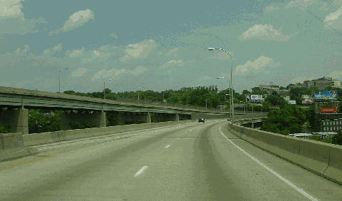
This 2002 photo shows the northbound Roosevelt Expressway (US 1) just beyond the interchange with the Schuylkill Expressway (I-76). The Roosevelt Expressway crosses the Schuylkill River over a pair of high-level viaducts. (Photo by Jim K. Georges.)
|
|
|
|
|
|
|
|
|
 |
|
|
|
|
 |
|
|
|
|
|
|
|
|
|
3.5 miles (5.6 kilometers)
1958-1961
|
|
|
|
|
|
|
|
|
 |
|
|
|
|
|
Height restrictions apply at Broad Street (PA 611). Overheight vehicles must exit at PA 611.
|
|
|
|
|
|
|
|
|
|
|
|
|
|
|
|
 |
|
|
|
|
|
THE DEVELOPMENT OF ROOSEVELT BOULEVARD: Known today by most motorists and residents as simply "the Boulevard," Roosevelt Boulevard was first proposed in 1902 as Torresdale Boulevard by Philadelphia mayor Samuel H. Ashbridge. Ashbridge, known as "Stars and Stripes Sam" for his patriotic speeches, pushed the project through the reluctant 135-member Common Council, the forerunner to the City Council.
|
|
|
|
|
|
|
|
|
|
|
|
|
|
Frank H. Massey, a Common Council member, real estate broker and chairman of the council's important Surveys Committee, assisted Ashbridge in his push for the boulevard. Massey described the project to the Council as follows:
The laying out of the avenue, as proposed, is for the purpose of bringing the large northeastern territory of the city into closer connection with the central portion, as well as for the development of a largely rural section into building sites. Such an avenue will doubtless become an important and beautiful thoroughfare. The cost of placing it on the city plan will be less now than at a future time. It will generally be limited to the cost of farmland.
The proposed boulevard was to have a 300-foot-wide right-of-way from Broad Street northeast to Torresdale. Connections were to be provided to Hunting Park Avenue and Bellfield Avenue. Much of the area through which the proposed boulevard passed consisted of self-supporting farming towns connected by wagon trails. With the new boulevard, these areas would be linked to Center City Philadelphia.
According to the official records of the city's Department of Streets, the original sections of Torresdale Boulevard opened in 1903, 1907, 1911 and 1914, at a total cost of $3.5 million. When it was completed, the road was renamed Northeast Boulevard. Soon after it was extended to Pennypack Creek in 1918, the boulevard was renamed after Theodore Roosevelt.
Roosevelt Boulevard became part of the Federal highway system in 1926 when the US 1 designation was added, and in 1937, the Philadelphia Department of Streets transferred the highway to the Pennsylvania Department of Highways (now the Pennsylvania Department of Transportation, or PennDOT). By 1960, subsequent additions northbound had taken Roosevelt Boulevard into Bucks County. As the boulevard was extended through the Far Northeast in the postwar years, developers followed soon thereafter.
Since the 1960s, PennDOT has constructed six 12-foot-wide lanes, in each direction, from Pennypack Circle to Bucks County. In addition, PennDOT constructed an overpass at Fifth Street, and underpasses at PennDOT constructed dedicated left-turn lanes at grade-level intersections.
|
|
|
|
|
|
|
|
|
|
|
|
|
|
|
|
|
|
|
|
 |
|
|
|
|
|
|
|
|
|
|
|
|
|
|
|
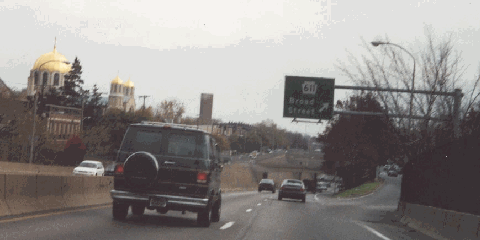
This 2000 photo shows the northbound Roosevelt Expressway (US 1) at the Broad Street (PA 611) exit in North Philadelphia. The inadequate shoulders and absence of acceleration-deceleration lanes are characteristic of the expressway's 1950s-era construction. (Photo by Steve Anderson.)
|
|
|
|
|
|
|
|
|
|
|
|
|
|
|
|
|
|
|
|
EXTENDING TO THE SCHUYLKILL EXPRESSWAY: First proposed by the Philadelphia City Planning Commission in 1947, the Roosevelt Expressway was designed to link Roosevelt Boulevard in the vicinity of Wingohocking Street (near Hunting Park) with the new Schuylkill Expressway. A full interchange was to be provided at Broad Street (PA 611). As originally planned, the expressway was to have six 12-foot-wide lanes (narrowing to four lanes just west of PA 611), eight-foot-wide shoulders, 14-foot-high clearances and a four-foot-wide median strip.
|
|
|
|
|
|
|
|
|
|
|
|
|
|
The Roosevelt Expressway crosses the Schuylkill River and East River Drive over a concrete and steel-girder structure to existing grade, then through a cut to the CSX-Conrail underpass. Overpasses carry Henry Avenue, Fox Street and Wissahickon Avenue over the expressway. At 17th Street, the expressway descends from existing grade to a depressed section, passing under 16th Street, 15th Street, Broad Street, Old York Road to Hunting Park Avenue, where the expressway ends. Partial interchanges are located at Ridge Avenue-East River Drive (southbound only), Fox Street (southbound only), Wissahickon Avenue (northbound only), Roberts Avenue (northbound only) and Hunting Park Avenue (US 13, southbound only).
|
|
|
|
|
|
|
|
|
|
|
|
At one point, a viaduct had been considered from Fern Hill Park to the Hunting Park Avenue terminus. However, because of high construction costs and concerns about potential adverse community impacts, the Philadelphia City Planning Commission decided against the viaduct, and instead recommended the depressed highway.
Constructed by the Pennsylvania Department of Highways, the 3.5-mile Roosevelt Expressway was completed in 1961 at a cost of $3.6 million. With the completion of the Roosevelt Expressway, a new link was provided from Northeast Philadelphia to the Schuylkill Expressway (I-76).
|
|
|
|
|
|
|
|
|
|
|
|
|
|
|
|
|
|
|
|
|
IMPROVING ROOSEVELT BOULEVARD AND EXPRESSWAY: According to PennDOT, Roosevelt Boulevard handles approximately 90,000 vehicles per day (AADT), while the Roosevelt Expressway handles approximately 110,000 vehicles per day. In early 2002, PennDOT and Philadelphia officials convened a task force to recommend improvements along the boulevard section. Some short-term improvements (such as improved signing) have already been implemented. The longer-term objectives of the task force focus on reconstruction of the boulevard section.
Separately, PennDOT is in the final design stages of rehabilitating both the boulevard and the expressway. The engineering firm Ammann and Whitney, which PennDOT commissioned to undertake the project, has developed the following elements of the final design:
adjustments to roadway geometry
rehabilitation of concrete decks on bridges
seismic analysis and retrofit of a pin and hangar assembly for a 2,587-foot-long, 15-span viaduct
drainage analysis and design
ramp lengthening and acceleration-deceleration lane improvements
improvements to highway lighting system
installation of variable message signs and other traffic control features
No schedule has been given for construction and completion dates.
|
|
|
|
|
|
|
|
|
|
|
|
|
|
 |
|
|
|
|
|
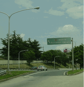
This 2002 photo shows an entrance ramp directing traffic to the northbound Roosevelt Expressway (US 1) in North Philadelphia. The sign in this photo dates from the early 1960s. (Photo by Jim K. Georges.)
|
|
|
|
|
|
|
|
|
|
|
|
|
|
|
|
|
|
|
|
|
 |
|
|
|
 |
|
|
|
|
 |
|
|
|
|
|
|
|
|
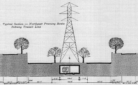
Typical cross-section of the Northeast Expressway (US 1) and Broad Street Subway extension along the Pennway-PECO alignment, as proposed in 1964. More than 40 years later, a new proposal to extend expressway and subway service into Northeast Philadelphia was proposed by the Philadelphia City Planning Commission and SEPTA. (Diagram by Turnpike Engineers Incorporated.)
|
|
|
|
|
|
|
|
|
|
|
|
|
|
|
|
|
|
|
|
A NEW EXPRESSWAY TO THE NEAR AND FAR NORTHEAST: The explosive growth of Northeast Philadelphia in the postwar years prompted officials to seek ways to relieve congestion on Roosevelt Boulevard. In the early 1960s, the Philadelphia City Planning Commission proposed a new expressway between Hunting Park Avenue and the Pennsylvania Turnpike-Delaware River Extension (I-276) in Bensalem, Bucks County.
|
|
|
|
|
|
|
|
|
|
|
|
|
|
The Northeast Expressway was to follow the alignment of the existing Roosevelt Boulevard to a point just east of Tacony Creek Park (near Friends Hospital). In this area, there was to have been a trumpet interchange with the unbuilt Pulaski Expressway (PA 90), which was to connect the Near Northeast with the Betsy Ross Bridge. North of the Pulaski Expressway interchange, the expressway was to veer north and west of the existing US 1 onto a new alignment. Along this "Pennway Corridor" alignment, which was to run roughly along Pennway Street and Northeast Avenue, interchanges were to be constructed with the unbuilt Ten-Mile-Loop Expressway (near PA 532) and the unbuilt Woodhaven Road Extension (PA 63). North of the Pennsylvania Turnpike, the expressway was to continue along the route of existing US 1 to Trenton.
The 14.9-mile-long expressway extension was estimated to cost $94 million. Another component of the Northeast Expressway was a proposed nine-mile-long, $94 million (separately funded) extension of the Broad Street Subway line. Both the expressway and the subway were to occupy the right-of-way of the existing PECO transmission line.
A typical section of the route was to be constructed as follows:
two 42-foot-wide depressed roadways, each accommodating two 12-foot-wide travel lanes, a 12-foot-wide outside shoulder and a six-foot-wide inside shoulder
a 56-foot-wide center median, accommodating the PECO transmission line and the Broad Street Subway line beneath
retaining walls and tree-lined malls of varying width between the expressway and surface streets
In anticipation of the subway extension portion of the project, Sears even built a subway station at its Northeast Philadelphia property, at a cost of $1 million. (The underground station, which was completed in 1967, was destroyed when the massive Sears complex was imploded in 1994.)
PennDOT acquired 100 properties between 1970 and 1974 along Roosevelt Boulevard and Adams Avenue in the area just east of Tacony Creek Park, in preparation of plans to build an interchange between the Northeast Expressway and the Pulaski Expressway. Many of the homeowners moved out, and 29 homes were demolished. However, PennDOT rented out some of the remaining homes as late as the early 1980's. With PennDOT retaining title to the homes, and homeowners unable to sell to anyone but PennDOT, the area declined through the rest of the 1970's.
KILLING THE NORTHEAST EXPRESSWAY: The first strike against the Northeast Expressway came in 1971, when Governor Milton Shapp ordered all re-evaluation of all highway programs statewide. Community and transit advocates saw this order as an opportunity to kill the expressway, and provide "Lindenwold-type public transportation for in-city use." However, city and state planners saw the order as an obstacle to a "good highway plan." In the absence of the expressway, drastic improvements to existing arterials would have to be made.
On July 1, 1977, PennDOT halted all funding on unbuilt highway projects. While this move killed most unbuilt expressways in the Philadelphia area, including much of the Northeast Expressway, two unbuilt sections - the Pulaski Expressway and part of the Northeast Expressway (connecting the Pulaski and Roosevelt expressways) - remained on state and city plans, since they were both under environmental review. Although PennDOT did not officially kill the Northeast Expressway - it insisted that the road still was being studied - an end to the road finally appeared in sight in 1980 when the Philadelphia City Highway Department commissioned studies for alternatives to the Northeast Expressway.
Joseph R. Syrnick, chief of the department's expressway unit, said of the Northeast and Pulaski expressways as follows:
The Pulaski Expressway is off the plans and out of the picture completely. And the Northeast Expressway is absolutely dead. It could not be revived.
The Philadelphia City Planning Commission subsequently removed the Northeast Expressway from its future capital program. Finally, state legislators from Philadelphia were so convinced that the two expressways were dead that they passed Act 100, which specifically provided that PennDOT could sell off properties no longer needed for expressway projects in the city.
From the beginning, the Northeast Expressway ran into opposition from residents and conservationists, who feared adverse impacts to the community and nearby Tacony Creek Park. Ultimately, PennDOT did not have enough money for the project.
|
|
|
|
|
|
|
|
|
|
|
|
|
|
|
 |
|
|
|
|
|
|
|
|
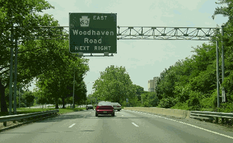
This 2002 photo shows the southbound Roosevelt Boulevard (US 1) approaching Woodhaven Road (PA 63) in Northeast Philadelphia. The 12-lane arterial has C/D roads, a landscaped center median and buffer zones. (Photo by Jim K. Georges.)
|
|
|
|
|
|
|
|
|
 |
|
|
|
|
|
|
|
|
|
|
REVIVING THE NORTHEAST EXPRESSWAY AND SUBWAY: In 1999, the Philadelphia City Planning Commission, PennDOT and the Southeastern Pennsylvania Transportation Authority (SEPTA) revisited the issue of improving highway and transit access to Northeast Philadelphia. One of the six alternatives proposes to extend the Roosevelt Expressway for 12.5 miles from Broad Street to Southampton Road. A spur of the SEPTA Broad Street subway line would be constructed from the Broad-Erie station along the expressway median to the Southampton Road terminus. Unlike earlier proposals, the routes would be constructed within existing rights-of-way.
|
|
|
|
|
|
|
|
|
|
|
|
|
|
From the Philadelphia City Planning Commission:
This alternative would lower than inner travel lanes below the cross streets and rely on ramps to move traffic between the outer roadways and the expressway lanes. The facility would look similar to the Vine Street Expressway. It was assumed that four lanes of limited-access highway could maintain the same capacity as the existing six-lane, at-grade express lanes. This realization presented the opportunity to reduce the highway cross-section and add a rail component while maintaining the existing right-of-way.
The typical cross-section of this alternative includes two 12-foot-wide depressed express travel lanes (and emergency shoulders) in each direction, and three 11-foot-wide at-grade travel lanes for local traffic on each side of the expressway. The physical alignment of Roosevelt Boulevard / Expressway will have minimal impact to the existing right-of-way due to the decrease in the number of express lanes from six (three lanes in each direction). The two rail tracks will generally run along the centerline of the expressway, and maintain the same profile as the expressway travel lanes. There is minimal impact to the horizontal alignment.
The three existing local lanes (in each direction) will remain at their current elevation. The profile of the express lanes, however, will change significantly. The express lanes will be depressed approximately 15 to 20 feet below their existing elevation. This will cause significant impact to existing underground utilities, and will require extensive coordination.
In existing conditions, motorists use crossovers to access the express lanes from the local lanes. Under proposed conditions, motorists will access the express lanes via slip ramps in the 30-foot-wide median that separates the express and local lanes. These slip ramps will be located prior to and after interchanges.
The new expressway alignment would begin where the existing Roosevelt Expressway currently terminates and travel north to Southampton Road. This highway alignment would require that the 5th Street overpass be demolished and rebuilt as an underpass. Intersecting streets would cross the expressway on overpasses.
A total of 12 new stations within the center of the expressway will serve the new corridor. (The new Broad-Roosevelt line will be also accessible from six existing stations on the Broad Street mainline: Erie, Girard, Spring Garden, Race-Vine, City Hall and Walnut-Locust.) Access to and from street level will be provided through stairs and elevators. At station locations, the depressed portion of the cross-section widens into the 30-foot-wide medians to accommodate the station platforms, and tapers back after the stations to provide the full 30-foot-width.
Once completed, the expressway and local lanes, which would be constructed within the existing 250-foot-wide right-of-way, are expected to carry approximately 100,000 vehicles per day (AADT). The proposed configuration would not only alleviate congestion, but also improve safety along the Roosevelt Boulevard corridor, which has been cited recently as one of the most dangerous in the county. However, some fear that construction of the depressed expressway would remove the existing greenery between the express and local lanes. For the transit component of the project, the subway extension is expected to carry approximately 130,000 riders per day, half of them new transit riders.
MASS TRANSIT AND EXPRESSWAY PROPOSALS BOTH PLACED ON HOLD: In December 2001, the Philadelphia City Planning Commission gave preliminary approval to a "local preferred alternative" ("alternative C-prime"), a proposal that would continue the Broad Street Line along Roosevelt Boulevard to Bustleton Avenue, and would tie in a proposed extension of the Market-Frankford Line at the Roosevelt Boulevard-Bustleton Avenue terminus. To cut down on costs, officials plan to build open-air, depressed subway stations wherever feasible. The $3.4 billion proposal does not include provisions for an extended expressway.
Despite this decision, a 2002 article in the Philadelphia Daily News suggested that an extension of the Roosevelt Expressway still had supporters among transportation engineers and safety experts. In light of this support, officials at the Philadelphia City Planning Commission advanced both "alternative C-prime" and "alternative D" to the environmental impact process in their February 2003 final report.
According to the 2003 report, construction was to begin in 2009 and extend until at least 2018. However, the proposal appears to be on hold as the Commission removed the plans from its web site.
|
|
|
|
|
|
|
|
|
|
|
|
|
|
|
 |
|
|
|
|
|
|
|
|
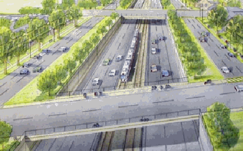
This drawing from the 2003 final report of the "Roosevelt Boulevard Corridor Study" shows the depressed four-lane Roosevelt Expressway and subway line at Rising Sun Avenue. Borrowing from the design of the Vine Street Expressway, the Roosevelt Expressway is shown flanked by three-lane service roads. Trees and other landscaping would be planted in the buffer zones next to the service roads. However, the city and state have placed the project on hold. (Drawing by Philadelphia City Planning Commission.)
|
|
|
|
|
|
|
|
|
|
|
|
|
|
 |
|
 |
|
|
|
|
|
EXTEND THE ROOSEVELT EXPRESSWAY: The "expressway and subway" alternative ("alternative D") proposed for the Roosevelt Boulevard corridor by the Philadelphia City Planning Commission should be implemented. Provisions should be made for a northerly extension of the Roosevelt Expressway to the Bucks County section of the US 1 Expressway.
|
|
|
|
|
|
|
|
|
|
|
|
|
|
|
|
|
To mitigate community impacts, the expressway and rail line should be covered along some stretches, as has been done for the Delaware and Vine Street expressways. Parks, gardens, playgrounds, and basketball courts could be built atop the covers.
|
|
|
|
|
|
|
|
|
 |
|
|
|
|
|
|
|
|
|
|
|
|
|
 |
|
|
|
|
|
SOURCES: "Philadelphia Expressway System," Philadelphia City Planning Commission (1947); "Schuylkill Expressway, Roosevelt Boulevard Expressway and Vine Street Expressway," Philadelphia City Planning Commission (1950); "Broad Street Subway Extensions," Turnpike Engineers Incorporated (1964); "Philadelphia's Comprehensive Plan for Expressways," Philadelphia City Planning Commission (1966); 1985 Regional Transportation Plan, Delaware Valley Regional Planning Commission (1969); "Shelving of Freeway Is Called Boon to Public" by Robert Fensterer, The Philadelphia Inquirer (5/06/1971); "Pulaski Expressway: Draft Environmental Impact Statement and Section 4(f) Statement," Pennsylvania Department of Transportation and Federal Highway Administration (1976); "Eleven Years in Bureaucratic Limbo" by Russell Cooke, The Philadelphia Inquirer (4/09/1981); Capital Program: City of Philadelphia, Philadelphia City Planning Commission (1981); "Schuylkill Carries the Load of Many Roads Left Unbuilt" by Paul Nussbaum, The Philadelphia Inquirer (8/19/1984); "The Boulevard: Lifeline of the Northeast" by Jerry W. Byrd, The Philadelphia Inquirer (1/29/1987); "Transportation Improvements: The Choice Is Yours" by David J. Foster, The Northeast News Gleaner (6/01/2001); "America's Ten Worst Intersections" by Bob McKeown, NBC News (6/26/2001); "Roosevelt Boulevard Corridor Study," Philadelphia City Planning Commission (2001); "Secrets Beneath the Streets" by Derrick Pitts, WHYY-TV (2001); "Our Highway of Death" by Myung Oak Kim, Philadelphia Daily News (4/03/2002); "Big Changes Ahead for Roosevelt Boulevard" by Cathy Gandolfo, WPVI-TV (9/05/2002); "Roosevelt Boulevard Corridor Study: Draft Final Report," Philadelphia City Planning Commission and Southeastern Pennsylvania Transportation Authority (2003); "Can Speed Cameras Fix Philly's Death-Trap Road?" by Dan McQaude, Philadelphia Magazine (1/21/2014); Ammann and Whitney; Jeff Kitsko; Scott Kozel; Dan Moraseski; Guy Olsen; Len Pundt; Sandy Smith.
US 1 shield by Ralph Herman.
Lightposts by Millerbernd Manufacturing Company.
|
|
|
|
|
|
|
|
|
|
|
|
|
|
|
|
 |
|
|
|
|
|
|
|
|
|
|
|
|
|
|
|
|
|
|
 |
|
|
|
|
|
|
|
|
 |
|
|
|
|
|
THE EXITS OF METRO PHILADELPHIA:
Roosevelt Expressway exit list by Steve Anderson.
|
|
|
|
|
|
|
|
|
|
|
 |
|
|
|
|
|
|
|
|
|
|
|
|
Site contents © by Eastern Roads. This is not an official site run by a government agency. Recommendations provided on this site are strictly those of the author and contributors, not of any government or corporate entity.
|
|
|
|
|
|
|
|
|
|