 |
|
|
|
|
|
|
|
|
|
|
|
|
|
|
|
|
|
|
|
|
|
|
|
|
|
|
|
|
|
|
|
|
|
|
|
|
|
|
|
|
|
|
|
|
|
|
|
|
|
|
|
|
|
|
|
|
|
|
|
|
|
|
|
|
|
|
|
|
|
|
|
|
|
|
|
|
|
|
|
|
 |
|
|
|
|
 |
|
 |
|
|
|
|
|
|
|
|
|
|
|
|
|
|
|
|
 |
|
|
|
|
|
|
|
|
|
|
|
|
|
|
|
 |
|
|
|
|
|
|
|
|
|
|
|
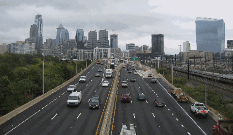
This 2007 photo shows the Schuylkill Expressway (I-76) near the Vine Street Expressway (I-676) and 30th Street Station. The Philadelphia skyline looms ahead to the southeast. (Photo by Steve Anderson.)
|
|
|
|
|
|
|
|
|
 |
|
|
|
|
 |
|
|
|
|
|
|
|
|
|
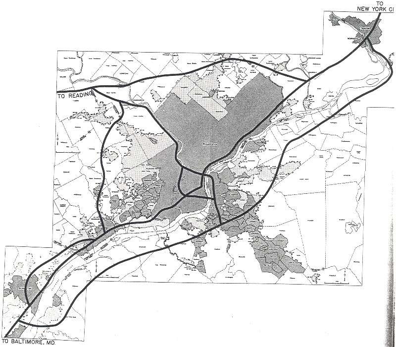
25.2 miles (40.6 kilometers)
1949-1959
|
|
|
|
|
|
|
|
|
 |
|
|
|
|
|
|
|
|
"If you don't like it, don't drive it." - Bill Allen, designing engineer of the Schuylkill Expressway
|
|
|
|
|
|
|
|
|
|
|
|
EARLY PLANS FOR A SCHUYLKILL RIVER PARKWAY: In 1932, the Regional Planning Federation (the predecessor agency to the Delaware Valley Regional Planning Commission, or the DVRPC) proposed a parkway system around the Philadelphia area similar to that constructed by Robert Moses. Like the Moses parkways in New York, the four-lane parkways were to feature controlled access, stone-arch bridges, timber lightposts and natural vegetation.
|
|
|
|
|
|
|
 |
|
|
|
|
|
|
|
|
|
|
The proposed riverfront route along the west bank of the Schuylkill River - the Valley Forge Parkway - was to connect Fairmount Park in Philadelphia with Valley Forge National Historic Park. An extension of the parkway was to continue northwest to Pottstown and Reading. Without a "power broker" like Moses to coordinate efforts, the parkway system never came to fruition. Nevertheless, officials kept the route planned as a restricted, cars-only artery as late as the mid-1940s.
PLANNING THE ROUTE FROM THE TURNPIKE TO CENTER CITY: In 1947, the Philadelphia City Planning Commission approved preliminary plans for developing the Schuylkill River route as an expressway. Borrowing from the "Valley Forge Parkway" design of the 1930's, the Schuylkill Expressway was to offer controlled access, but unlike the parkway design, which was to permit access only to passenger cars, the expressway design was to also permit access to trucks and buses.
The Commission offered the following two alternatives for the expressway:
One plan called for an alignment along today's I-76 route through Philadelphia, including the construction of a new crossing (Walt Whitman Bridge, originally planned as the "Delaware Tunnel") across the Delaware River. This plan was ultimately adopted.
Another plan called for a slightly different route for the Schuylkill River. Instead of crossing the Schuylkill River just south of University City, the expressway was to be routed along the west bank of the river to Southwest Philadelphia, near Philadelphia International Airport. A tunnel was to be constructed from the Hog Island-Essington area to Paulsboro, New Jersey. However, the planned expansion of the airport (located at the northern end of the proposed tunnel approach) ultimately thwarted this plan.
|
|
|
|
|
|
|
|
|
|
|
|
|
|
|
|
|
In 1948, when the Pennsylvania Turnpike (I-76) was being extended east from Harrisburg to Valley Forge, officials at the Pennsylvania Department of Highways and the Pennsylvania Turnpike Commission considered two extensions. One extension, a continuation of the mainline toll road (the "Delaware River Extension"), was to extend east through Bucks County to meet the mainline New Jersey Turnpike in Burlington County, New Jersey. The second extension, a freeway that would eventually become the Schuylkill Expressway, was to extend southeast toward Center City Philadelphia.
|
|
|
|
|
|
|
|
|
|
|
|
|
|
|
|
|
|
|
|
|
|
|
|
|
The Philadelphia City Planning Commission recognized the need for a regional network of expressways, beginning with the Schuylkill Expressway. Excerpts of the Commission's 1950 report were as follows:
The Pennsylvania Department of Highways contemplates the early construction of a controlled-access highway from the eastern terminus of the Pennsylvania Turnpike at the intersection of US 202 and PA 23 at King of Prussia, to the Montgomery-Philadelphia county line near the Schuylkill River Bridge on City Avenue. This will justify a new artery within the City of Philadelphia to handle the traffic, as the existing highway facilities in the vicinity of City Avenue are inadequate even for present traffic.
The Commonwealth has recognized that inter-regional highways connecting industrial and consumer centers can be fully effective in building up the economic vitality of the state only if adequate and efficient links are developed to the major destinations in the cities. Therefore, it has included in its program the construction of the Schuylkill Expressway, Vine Street Expressway and Roosevelt Expressway, which would carry traffic from other parts of the state highway system and the Pennsylvania Turnpike to the city center, to the industry of Northeast Philadelphia and South Philadelphia, and to the Port of Philadelphia. Of perhaps even greater importance, these highways would provide necessary links in the internal circulation system of the city, in accordance with a comprehensive plan prepared by the City Planning Commission, thereby adding to the convenience and efficiency of the city structure.
Philadelphia, in common with all great urban concentrations, faces a problem of restoring a reasonable balance to the use of its existing streets. The solution to this problem lies in the construction of a network of express highways meeting modern standards, located so that they will not blight existing development or inhibit new growth and rehabilitation, and in a manner to afford a measure of relief for the general street pattern.
Obviously, one new cannot revitalize the entire circulatory system of a great city. The proposals for the Schuylkill Expressway are among the first comprehensive moves to relieve Philadelphia's traffic congestion. Its limitations as well as its potentialities must be recognized.
|
|
|
|
|
|
|
|
|
|
|
|
|
|
|
|
|
 |
|
|
|
|
|
|
|
|
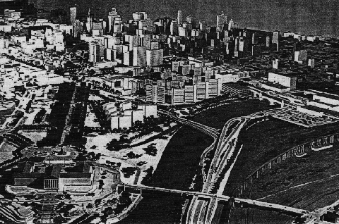
The Schuylkill Expressway, as proposed looking southeast in this artist's rendition from 1950. From the Schuylkill / Vine interchange shown here, the Vine Street Expressway veers left across the Schuylkill River, while the Schuylkill Expressway continues to the right. On the right are 30th Street Station and the Pennsylvania Railroad yards. (Artist's rendition by Philadelphia City Planning Commission.)
|
|
|
|
|
|
|
|
|
|
|
|
|
|
|
|
|
|
|
|
A TALE OF TWO DESIGN ENGINEERS: Two men with differing ideas handled much of the design work on the Schuylkill Expressway. Michael Rapuano, a New York engineer who worked on the design of the Garden State Parkway, believed that expressways should be safe and pleasant. Bill Allen, vice president of the engineering firm Gannett Fleming (which did the contractual work for the Pennsylvania Department of Highways), believed that expressways were to embody the streamlined efficiency of the postwar era.
|
|
|
|
|
|
|
|
|
|
|
|
|
|
In designing the Schuylkill Expressway, Michael Rapuano borrowed the route and design precepts of the original Valley Forge Parkway proposal. Along the 25-mile-long expressway route, most of which follows the contour of the Schuylkill River, Rapuano faced geographic and aesthetic challenges. Through Montgomery County, he had to weave an expressway through the steep slopes along the west bank of the river, around a historic railroad tunnel without damaging it, and under the narrow arches of the Pencoyd Viaduct.
Moving southeast into Philadelphia, Rapuano spent two years trudging through Fairmount Park, trying to find a way to bring the expressway through the park without ruining this urban retreat. One of his solutions was to elevate the proposed expressway on a 100-foot-high platform through one mile of the park. Opponents, horrified at the idea of directing the expressway through the park, were somewhat mollified when Rapuano took them along the route to demonstrate the view of the city that this elevated stretch would provide. Although the stretch through the park was not the elevated roadway that he envisioned, Rapuano achieved a victory in the progress of the Schuylkill Expressway.
Meanwhile, Bill Allen, who understood that highway engineering, with all its attendant political problems, was the art of the impossible, charted a more pragmatic course in his design of the Schuylkill Expressway. Since resistance came from all fronts - from the communities through which it would be built, from the environmentalists who feared that Fairmount Park would be ruined (and that access to the Schuylkill River would be cut off), from the railroads whose tracks paralleled the route of the expressway, and from the University of Pennsylvania whose athletic fields would have to be sacrificed - Allen followed the path of least resistance by designing a riverside route, trying to squeeze in lanes wherever he could. This legacy lives on today in the form of underpowered interchanges (including the median "SPUI" at EXIT 346A / South Street), and the absence of acceleration-deceleration lanes.
Perhaps the most complex engineering challenge lay in the area of 30th Street Station. Here, the Pennsylvania Railroad, which needed a significant amount of land for its switching yards, was unwilling to part with any of this land. Not much land was left to squeeze in a four-lane expressway between the station and the Schuylkill River. To accomplish this feat, Allen and his colleagues had to move the south bank of the river by eight feet. They drove piles down into the river and built a concrete structure to accommodate the right-hand westbound lane. Even with all that, the only way Allen could align the roadway left just two feet of clearance on either side.
Reflecting upon this feat, Allen replied in a 1983 interview with The Philadelphia Inquirer:
That's right. Just two feet. That's how close you are to the corner of the concrete abutment as you travel through that underpass down by 30th Street Station. Most people don't realize it because it's dark in there and they're moving pretty fast
It was either a two-foot clearance or an expressway that stops just east and west of 30th Street Station.
|
|
|
|
|
|
|
|
|
|
|
|
|
|
 |
|
 |
|
|
|
|
|
|
|
|
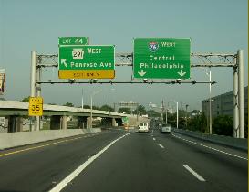
These 2000 photos show the reconstructed westbound Schuylkill Expressway (I-76) at EXIT 348 (PA 291 / Penrose Avenue, left photo) and EXIT 345 (30th Street Station). (Photos by Jim K. Georges.)
|
|
|
|
|
|
|
|
|
|
|
|
|
|
|
|
|
|
|
|
DESIGN AND CONSTRUCTION: As originally planned in 1948, the Schuylkill Expressway was to extend for 20 miles from the Pennsylvania Turnpike-Valley Forge interchange southeast to the University Avenue bridge over the Schuylkill River. Later, the route was extended for five miles to the proposed Walt Whitman Bridge. Part of this newly extended route was to utilize an alignment along Vare Avenue and South 26th Street.
|
|
|
|
|
|
|
|
|
|
|
|
|
|
The entire length of the expressway was to have four 12-foot-wide lanes, two lanes in each direction, and (wherever possible) 8-foot-wide shoulders. Along the following two stretches, six lanes were to be provided:
from EXIT 339 (US 1-City Avenue) east to EXIT 344 (I-676 / US 30 / Vine Street Expressway)
from EXIT 346B (University Avenue-Grays Ferry Avenue ) east to EXIT 347B (Passyunk Avenue-Oregon Avenue)
There were to be 19 eastbound on-ramps, 22 eastbound off-ramps, 21 westbound on-ramps and 25 westbound off-ramps.
Roadways were separated by a four-foot-wide median strip, atop which were to be placed mountable, reflectorized curbs. Wherever possible, divided roadways were constructed in order "to take greatest advantage of the attractive views from the hillside of Schuylkill River valley and the distant skyline of the Center City area." The maximum gradient was not to exceed three percent, and the minimum clearance was not to be below 14 feet. The design speed was established at 50 MPH through the city of Philadelphia, and 60 MPH through Montgomery County.
Construction of the first expressway section between Valley Forge and the Philadelphia city line began in 1949. When this initial section through Montgomery County opened on September 1, 1954, The Philadelphia Evening Bulletin reported of huge traffic jams developing on City Line Avenue and through Fairmount Park at the expressway's eastern terminus. News of the monumental traffic jam even made it into The New York Times.
Over the next several years, construction progressed through the city of Philadelphia. Even as construction went forward, financial problems at the Pennsylvania Department of Highways - which was backlogged by a number of war-deferred projects - caused delays. This predicament was eased significantly with the passage of the 1956 Federal Highway Act. On June 30, 1959, officials opened the final section of the Schuylkill Expressway - located near 30th Street Station and the Vine Street Expressway - to traffic.
As the expressway was completed through Philadelphia in the late 1950's, Mayor Richardson Dilworth served as the main dignitary at the ribbon-cutting ceremonies. Inevitably, Dilworth became linked to the Schuylkill Expressway, and after leaving the mayor's office in 1962 to run unsuccessfully for governor, he never held elective office again. In his own words, Dilworth called the road "the worst mistake in my administration." His lament was not for the inadequacies of the expressway, but rather for its effects on the once-tranquil Fairmount Park.
|
|
|
|
|
|
|
|
|
|
|
|
|
|
|
 |
|
|
|
|
|
|
|
|
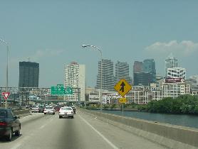
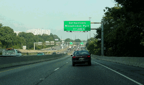
This 2003 photo shows the westbound Schuylkill Expressway (I-76) approaching EXIT 340A (Lincoln Drive / Kelly Drive) and the Philadelphia city line. The dual-dual roadways at this location for traffic entering and exiting US 1, which shares the expressway with I-76 for about one mile. (Photo by Jim K. Georges.)
|
|
|
|
|
|
|
|
|
|
|
|
|
|
|
|
|
|
|
 |
|
|
|
|
|
|
|
|
|
|
THE SCHUYLKILL BECOMES AN INTERSTATE: Through the early-to-mid 1950s, the cost of constructing the Schuylkill Expressway was split 50-50 between the state and Federal governments. While the Federal Bureau of Public Roads (BPR) included the Schuylkill Expressway in the preliminary Interstate highway system, the expressway did not officially become part of the Interstate highway system until 1956. New sections were henceforth eligible for 90 percent Federal funding; the state paid the remaining ten percent of construction and right-of-way costs.
|
|
|
|
|
|
|
|
|
|
|
|
|
|
The Schuylkill Expressway, which previously had been designated PA 43, had the following Interstate designations over the years:
June 1958-October 1958: I-280 from Valley Forge to the Walt Whitman Bridge. Pennsylvania officials proposed this designation.
October 1958-November 1958: I-380 from Valley Forge to Center City (Vine Street Expressway); I-395 from Center City to the Walt Whitman Bridge. New Jersey officials suggested these separate designations to correspond with that state's proposed Interstate segments.
November 1958-early 1964: I-80S from Valley Forge to Center City (Vine Street Expressway); I-680 from Center City to the Walt Whitman Bridge. These were the final designations given by the American Association of State Highway Officials (AASHO).
1964-1973: I-76 from Valley Forge to Center City (Vine Street Expressway); I-676 from Center City to the Walt Whitman Bridge; approved by AASHO. The I-76 designation was desired because none of the existing spur routes (I-180, I-280, I-480 and I-680) touched their parent route. Designations on the spur routes also were changed.
1973-present: I-76 along entire length from Valley Forge to the Walt Whitman Bridge. (Interestingly, the current routing of the I-76 designation from the Ohio border to the Walt Whitman Bridge had been suggested by some Pennsylvania officials since 1963.)
Despite its Interstate designation, the Schuylkill Expressway did not meet contemporary standards, as described in the following 1969 excerpt from The Philadelphia Inquirer:
In retrospect, it might have been wiser to wait for those (Interstate) funds. At least then the expressway would have incorporated all the higher engineering standards required
The expressway doesn't uniformly meet Interstate standards, and some of its most accident-ridden locations are in those non-standard sections.
From the beginning, traffic demand exceeded the supply of available lanes. In 1950, planners estimated that by 1970, the daily traffic volume would total 35,000 vehicles per day (AADT). By 1960, one year after the entire expressway opened, the volume had approached 70,000 vehicles per day.
AMBITOUS ATTEMPTS TO ADD CAPACITY: In 1960, one year after completion, the Pennsylvania Department of Highways performed the first operational study of the Schuylkill Expressway. Even at this early date, officials acknowledged the many inherent design deficiencies of the existing expressway, and proposed some ambitious alternatives to improve safety and add capacity.
Two years later, the Pennsylvania Department of Highways proposed a parallel route - the Manayunk Expressway - along the eastern bank of the Schuylkill River. Although it was announced with great fanfare, the Manayunk Expressway proposal was quickly shelved amid fears that the eastern bank of the river would be paved over.
The state also pursued an ambitious plan to widen the Schuylkill Expressway to eight lanes. One part of this plan would have placed four eastbound lanes above the Pennsylvania Railroad (CSX) viaduct that sweeps to the west of 30th Street Station, and south through the former Philadelphia Bulletin property, University of Pennsylvania athletic fields and Philadelphia Civic Center. The existing expressway through this area would have been converted into four westbound lanes. (An alternative plan developed by the DVRPC would have had two-way express traffic utilizing the new four-lane elevated section over the railroad right-of-way, while local Center City traffic was to use the existing four-lane section.) The 2.5-mile-long, $25 million "Schuylkill Relief Route" proposal, which would have allowed more breathing room through the most congested section of the Schuylkill Expressway, was scheduled for completion by the bicentennial celebration year of 1976.
Although costly, the proposal had the support of the Pennsylvania Department of Highways, the Pennsylvania Railroad and the City of Philadelphia. However, it drew fierce opposition from the (now-folded) Bulletin, which at the time was the most widely read newspaper in Philadelphia. The Bulletin, which had constructed a new facility on Market Street, did not want the elevated expressway through their property, even with the sound barriers that had been included in the proposal. Under pressure from the Philadelphia establishment, which historically had been cool to the Schuylkill Expressway, Allen withdrew his proposal.
However, the state did manage to complete a portion of the widening project, albeit a scaled-down version. A three-year-long project to widen the expressway to six lanes (three in each direction), from EXIT 339 (US 1 / City Avenue) east to EXIT 341 (Montgomery Drive-West River Drive), was completed in 1972. At EXITS 339-340 (US 1 and Lincoln Drive-Kelly Drive), the interchange was rebuilt with wider roadways and new collector-distributor (C/D) roads.
|
|
|
|
|
|
|
|
|
|
|
|
|
|
|
 |
|
|
|
|
|
|
|
|
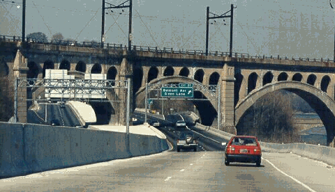
This 1987 photo shows the westbound Schuylkill Expressway (I-76), just before the Pencoyd Viaduct in Bala Cynwyd. More than a century old, the arched viaduct carried SEPTA commuter rail (R6-Manayunk line) service until 1990. (Photo by Scott Kozel.)
|
|
|
|
|
|
|
|
|
|
|
|
|
|
|
|
|
|
|
|
EARLY PLANS FOR RECONSTRUCTING THE SCHUYLKILL: In 1969, with the average section of the Schuylkill Expressway carrying more than 80,000 vehicles per day, the Pennsylvania Department of Highways began a second operational study on the route, this time focusing on the section from Center City northwest to Valley Forge. One year later, the state made the following observations:
|
|
|
|
|
|
|
|
|
|
|
|
|
|
While the expressway is somewhat below present freeway design standards, a great deal of skill was exercised in its layout. Alternatives of location and alignment were severely limited by difficult riverfront topography, myriad cross structure, and restrictions caused by the Schuylkill River, railroad facilities and industrial complexes. A major river crossing, the Penn Central (30th Street) Station plaza and the rolling countryside in the northwest area added to the complexities of design and construction.
Despite these inherent handicaps, the thoroughfare has afforded excellent service; accommodating peak-hour traffic flows equal or to exceeding those on many other expressways built to higher design standards. Increasing traffic demands, however, have produced congestion during peak hours extending over major sections of the route.
Previous studies of the expressway have resulted in recommendations to improve its capacity through major geometric modifications. The restrictions that affected the original design are still present, however, and widening or other reconstruction of the facility would be difficult and expensive.
Although the 1970 study did not specifically recommend adding capacity (lane-miles) to the expressway, it did advocate constructing acceleration-deceleration lanes, adding shoulders and installing ramp control meters. It also recommended building a new ramp from the western terminus of the Vine Street Expressway to West River Drive (taking local westbound traffic off the Schuylkill Expressway), and closing ramps in the area of 30th Street Station during peak periods.
Also in 1970, transportation consultants Alan M. Vorhees and Associates released the "South Central Transportation Study," a series of recommendations regarding the proposed Crosstown Expressway and connecting routes to Southwest Philadelphia and Center City, before the Philadelphia City Planning Commission. Although the report urged against constructing the full-length Crosstown Expressway (I-695), it did advocate the following measures:
widening the Schuylkill Expressway from four lanes (two in each direction) to at least six lanes (three in each direction) between the Pennsylvania Turnpike and the Walt Whitman Bridge (this expensive recommendation was repudiated by the 1970 state study)
constructing the "Grays Ferry Spur," a short controlled-access spur along Grays Ferry Avenue; this was to be an extension of the (unbuilt) Cobbs Creek Expressway (I-695)
constructing a new ramp from the westbound (northbound) Schuylkill Expressway to eastbound Walnut Street
While all of the measures in both studies were to manage congestion and improve access, none of them were ever implemented.
|
|
|
|
|
|
|
|
|
|
|
|
|
|
|
 |
|
|
|
|
|
|
|
|
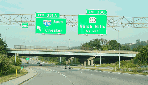
This 2003 photo shows the westbound Schuylkill Expressway (I-76) at EXIT 331 (I-476 / Mid-County Expressway / "Blue Route"). The ramps to northbound I-476 were opened in 1979, while the ramps to southbound I-476 were opened in 1991. (Photo by Jim K. Georges.)
|
|
|
|
|
|
|
|
|
|
|
|
|
|
|
|
|
|
"We all know that if a bird flies over the Schuylkill Expressway, there is an impact." - Andrew Warren, PennDOT district administrator
|
|
|
|
|
|
|
|
|
|
|
|
RECONSTRUCTION AND THE SCHUYLKILL SQUEEZE: In the mid-to-late 1970s, community opposition, fiscal constraints and the oil crises killed much of the proposed expressway network in Philadelphia. With all of the traffic that was supposed to use radial expressways now forced onto the Schuylkill Expressway, time and heavy usage together took their toll. The following excerpt from The Philadelphia Inquirer described what had become of the "Surekill" Expressway:
|
|
|
|
|
|
|
|
|
|
|
|
|
|
|
|
|
|
In most places it is four lanes wide, divided down the middle by a raised mound of concrete and a guardrail that's just under three feet high - substandard height. Atop the guard rail on some stretches is a filthy screen, flapping loose here and there. In the city, where road shoulders are so narrow that there's no room to maneuver, changing lanes becomes an act of war. The road surface is so worn and cracked that in many places you can actually see the steel gridwork that three decades ago lay covered by two inches of concrete.
In 1983, Henry Reichner, executive vice president of the Philadelphia Chamber of Commerce, made the following case for a complete overhaul of the Schuylkill Expressway:
The Schuylkill Expressway doesn't need repairs. It is beyond repair. What we need to do is tear it up and start all over again, and this time do it right.
With mounting life and property losses from accidents, as well as losses from lawsuits levied against it, the Pennsylvania Department of Transportation (PennDOT) announced a $250 million, four-year plan to refurbish 20 miles of the expressway between Valley Forge and the Schuylkill River Bridge. Improvements to the pre-Interstate era expressway were made as follows:
Constructing a new skid-resistant, virtually maintenance-free pavement along the entire length of the project. (Ultimately, this new surface had worn out more rapidly than expected, and was replaced in the late 1990's.)
Constructing a redesigned interchange to replace the existing interchange at EXIT 344 (I-676 / US 30 / Vine Street Expressway).
Redecking, repaving and reconstructing 50 bridges.
Refurbishing the expressway underneath the historic Pencoyd Viaduct without disturbing road and rail traffic.
Installing new concrete ("Jersey") barriers to replace steel guardrails in the median.
Installing new reflective signs to replace aging button-copy signs.
Improving shoulders, entrance and exit ramps, and acceleration-deceleration lanes.
Improving drainage to reduce the frequency of floods on the expressway.
Jeff Greene, the PennDOT administrator who oversaw the entire Schuylkill Expressway renovation project, offered the following vision:
With only one lane open in each direction, even if it keeps moving all the time, what you're going to have is a line of traffic essentially waiting to get into or out of the city. Anyone used to the Schuylkill Expressway as a convenient way of getting into and out of Center City is going to be very, very frustrated. I know if I commuted to work on the Schuylkill Expressway, I'd start planning right now for a different way of getting to work.
What became known as "the Schuylkill squeeze" began on March 1, 1985. There were some notable successes, such as the reconstruction of the expressway under the Pencoyd Viaduct. However, one significant setback during the project was the discovery that new Schuylkill-Vine Street interchange was beginning to sink under its own weight because of a design flaw. The interchange design flaw was rectified by using a new type of lightweight concrete resting on steel beams, and hammering them deep into the ground until they came to rest on bedrock to keep the interchange from sinking.
After more than four years of forcing motorists through single-lane "cattle chutes" and clogged alternate routes, PennDOT completed the Schuylkill Expressway project in September 1989. The "Schuylkill squeeze" had come to an end.
However, it did not take long for construction crews to return to the Schuylkill Expressway. Over a three-year period beginning in August 1996, the expressway was reduced to one lane in each direction while PennDOT crews patched, milled and resurfaced the road from the Pennsylvania Turnpike junction in Valley Forge to EXIT 346A (South Street). To minimize the impact of construction, all work was done during the nighttime hours.
|
|
|
|
|
|
|
|
|
|
|
|
|
|
|
 |
|
|
|
|
|
|
|
|
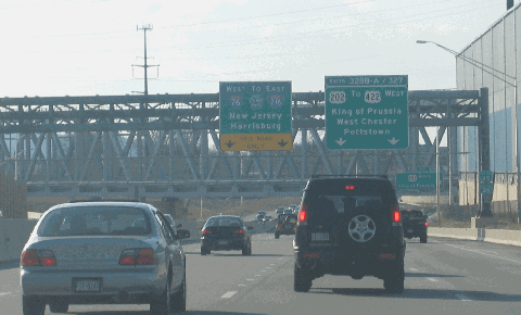
This 2005 photo shows the westbound Schuylkill Expressway (I-76) approaching EXITS 328-327 (US 202 Expressway) in King of Prussia. This stretch of expressway was rebuilt during the early 2000s as part of the US 202 reconstruction project. (Photo by Steve Anderson.)
|
|
|
|
|
|
|
|
|
|
|
|
|
|
|
|
|
|
|
|
CURRENT AND FUTURE IMPROVEMENTS: In recent years, PennDOT completed the following projects on the Schuylkill Expressway:
In Philadelphia, PennDOT rehabilitated the Girard Avenue Bridge (US 13) over the Schuylkill River and the expressway at EXIT 342. The $1.5 million project was completed in 2001.
|
|
|
|
|
|
|
|
|
|
|
|
|
|
Further south, at EXIT 346A in University City, PennDOT plans replace the South Street bridge over the expressway, the adjacent CSX-Conrail tracks, and the Schuylkill River after debris from fell onto I-76 on three separate occasions. The existing bridge, which has two travel lanes and a center left-turn lane, will be replaced with a four-lane bridge with a center left-turn lane, five-foot-wide bike lanes on both sides of South Street, and two five-foot-wide sidewalks. The $50 million project, which is scheduled to begin in late 2007 and continue through 2011, does not include a realignment of the existing "SPUI" ramps to I-76.
At EXITS 339-340 (US 1 and Lincoln Drive-Kelly Drive), PennDOT rehabilitated several bridges at the massive interchange. The $10 million project was finished in 2004.
Along the entire length of the Schuylkill Expressway in Philadelphia, PennDOT plans to install variable message signs and traffic detectors. The $7.0 million project was completed in 2002.
In Montgomery County, PennDOT recently completed work at EXIT 327 (Valley Forge-Mall Boulevard) and EXIT 328 (US 202 Expressway) in King of Prussia in 2001 as part of the $290 million US 202 Expressway (Section 400) reconstruction project. New ramps and collector-distributor (C/D) roads were built to provide direct access between I-76, US 202 and US 422. Other area improvements included building a new Norfolk Southern railroad truss bridge over I-76 to accommodate the additional lanes and ramps, widening I-76 between Croton Road and Mall Boulevard, building a multi-use trail bridge over I-76, and erecting sound barriers along I-76 between US 202 and Croton Road. For several months in early 2001, construction in this area was hampered by emergency work to stabilize sinkholes. In December 2001, the first of six new ramps opened to traffic. The interchange was completed in October 2003 to coincide with the opening of the improved US 202 Expressway.
During 2001, PennDOT replaced the sequentially numbered exit tabs with new mileage-based exit tabs. The new mileage-based exit numbering system on the Schuylkill Expressway complies with the system used in many states, and has been introduced recently throughout Pennsylvania.
According to the DVRPC, the Schuylkill Expressway carries approximately 95,000 vehicles per day (AADT) through Montgomery County, rising to approximately 135,000 vehicles per day near Center City Philadelphia.
REVISITING ADDED-CAPACITY PLANS: In 1997, the Neighborhood Club, a civic organization from Bala Cynwyd, recommended the construction of a second deck on the Schuylkill Expressway along the 18-mile stretch between King of Prussia and 30th Street Station. Trucks and buses would use the four-lane lower deck, while passenger cars would use the four-lane upper deck. In the median of the upper deck would be two tracks for light rail use. PennDOT has not commented on this plan, which appears destined to suffer the same fate as the Manayunk Expressway and Schuylkill Relief Route proposals.
More recently, the DVRPC rejected long-range plans for widening the Schuylkill Expressway to six lanes between City Line Avenue and the Pennsylvania Turnpike. The recommendation from the "2025 Long-Range Plan for the Delaware Valley" is contingent upon construction of the 62-mile-long Schuylkill Valley Metro light rail line from Philadelphia to Reading.
LANDMARK STATUS FOR THE SCHUYLKILL? During the late 1990's, the Schuylkill Expressway was considered for inclusion as a national landmark because of its historic importance in the region. However, because it was built as a reactionary rather than innovative solution to growing congestion, and because it had been significantly altered over the years, the expressway was not considered for inclusion.
|
|
|
|
|
|
|
|
|
|
|
|
|
|
 |
|
 |
|
|
|
|
|
|
|
|
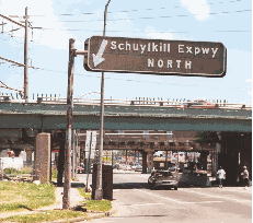
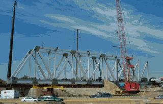
THE OLD AND THE NEW... LEFT: This 2000 photo shows a directional sign leading to the Schuylkill Expressway in South Philadelphia. This sign, which lacks an Interstate shield and has a "NORTH" direction, dates back to the late 1950's. (Photo by Alex Nitzman.) RIGHT: This 2002 photo shows the new Norfolk Southern railroad bridge being erected just off-site from its permanent location just southeast of the I-76 / US 202 interchange. The truss bridge was hoisted into place in October 2002, necessitating the closure of the Schuylkill Expressway during the overnight hours. (Photo by Pennsylvania Department of Transportation.)
|
|
|
|
|
|
|
|
|
|
|
|
|
|
|
|
|
|
|
 |
|
|
|
 |
|
|
|
|
|
SOURCES: Regional Plan of the Philadelphia Tri-State District, Regional Planning Federation (1932); "Vine Street Expressway," Philadelphia City Planning Commission (1945); "Philadelphia Expressway Program," Philadelphia City Planning Commission (1947); "Schuylkill Expressway, Roosevelt Boulevard Expressway and Vine Street Expressway," Philadelphia City Planning Commission (1950); "Pennsylvania Turnpike System," Pennsylvania Turnpike Commission (1951); "Expressway Brings Jam," The New York Times (9/03/1954); "New Roads with New Numbers Will Parallel Old U.S. Routes" by George Cable Wright, The New York Times (9/19/1958); Pennsylvania: Keystone of the Interstate Highway System, Chamber of Commerce of Greater Philadelphia (1958); "Philadelphia Road Link Opened," The New York Times (6/28/1959); "Schuylkill Expressway Operations Study," Pennsylvania Department of Highways (1960); "16-Mile Expressway Planned on East Side of the Schuylkill," The Philadelphia Evening Bulletin (2/01/1962); "16-Mile Expressway on East Side of Schuylkill Planned by State," Keystone Motorist-Keystone Automobile Club (February 1962); "Philadelphia's Comprehensive Plan for Expressways," Philadelphia City Planning Commission (1966); "Extra Lanes Planned for Expressway" by Saul Kohler, The Philadelphia Inquirer (9/05/1968); "Schuylkill Expressway: The Hardening Artery" by Louis E. Keefer, The Philadelphia Inquirer (11/23/1969); 1985 Regional Transportation Plan, Delaware Valley Regional Planning Commission (1969); "Schuylkill Expressway Operations Study," Pennsylvania Department of Highways (1970); "South Central Transportation Study," Alan M. Vorhees and Associates (1970); "The Schuylkill: The Road That Can't Be Fixed" by Mark Bowden, The Philadelphia Inquirer (4/17/1983); "On Philadelphia's Schuylkill Expressway, Sometimes Called the 'Surekill,'" The New York Times (7/13/1984); "Schuylkill Carries the Load of Many Roads Left Unbuilt" by Paul Nussbaum, The Philadelphia Inquirer (8/19/1984); "Schuylkill Expressway Improvement Project," Pennsylvania Department of Transportation (1986); "A New Life at the End of the Roadwork" by Laurie Hollman, The Philadelphia Inquirer (9/17/1989); "PennDOT Steers Expressway onto Road to Repair" by Suzanne Gordon, The Philadelphia Inquirer (8/14/1996); "Gridlock Solution on Deck" by John George, Philadelphia Business Journal (7/04/1997); "Rebuilding US 202 (Section 400) Today for a Better Tomorrow," Pennsylvania Department of Transportation (1997); Divided Highways by Tom Lewis, Viking-Penguin Books (1997); "The Importance of Using Context To Determine the Significance of Dualized Highways" by James Patrick Harshbarger and Mary E. McCahon, National Trust for Historic Preservation (4/08/2000); "First Came Sinkholes, Next New Jams on the Schuylkill" by Jere Downs, The Philadelphia Inquirer (3/09/2001); "Route 202 Project Comes to an End" by Jere Downs, The Philadelphia Inquirer (10/30/2003); "Was I-76 Numbered to Honor Philadelphia for Independence Day, 1776?," Federal Highway Administration (2004); Robert Donatucci; Jeff Kitsko; Scott Kozel; Raymond C. Martin; R. Bradley Maule; Alex Nitzman; Anthony Panichelli; Len Pundt; Sandy Smith; Stephen Summers; Jeff Taylor.
I-76 shield by Ralph Herman.
Lightposts by Millerbernd Manufacturing Company.
|
|
|
|
|
|
|
|
|
|
|
|
|
|
|
|
 |
|
|
|
|
|
|
|
|
|
|
|
|
|
|
|
|
|
|
 |
|
|
|
|
|
|
|
|
|
 |
|
|
|
|
|
THE EXITS OF METRO PHILADELPHIA:
Schuylkill Expressway exit list by Steve Anderson.
|
|
|
|
|
|
|
|
|
|
|
 |
|
|
|
|
|
|
|
|
 |
|
|
|
|
|
|
|
|
|
|
|
|
Site contents © by Eastern Roads. This is not an official site run by a government agency. Recommendations provided on this site are strictly those of the author and contributors, not of any government or corporate entity.
|
|
|
|
|
|
|
|
|
|