 |
|
|
|
|
|
|
|
|
|
|
|
|
|
|
|
|
|
|
|
|
|
|
|
|
|
|
|
|
|
|
|
|
|
|
|
|
|
|
|
|
|
|
|
|
|
|
|
|
|
|
|
|
|
|
|
|
|
|
|
|
|
|
|
|
|
|
|
|
|
|
|
|
|
|
 |
|
|
|
|
 |
|
 |
|
|
|
|
|
|
|
|
|
|
|
|
|
|
|
|
 |
|
|
|
|
|
|
|
|
|
|
|
|
|
|
|
 |
|
|
|
|
|
|
|
|
|
|
|
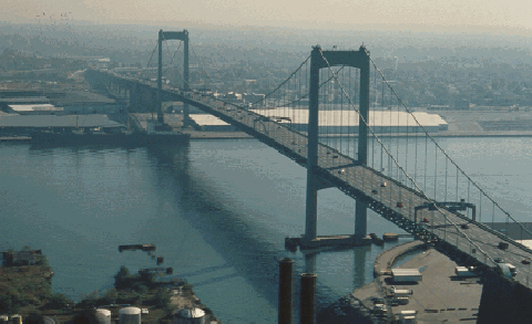
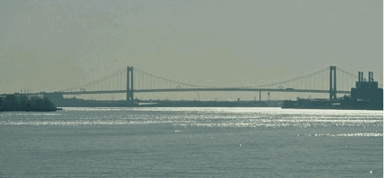
Part of I-76, the Walt Whitman Bridge spans the Delaware River between South Philadelphia and Gloucester City, New Jersey. (Photo by Delaware River Port Authority.)
|
|
|
|
|
|
|
|
|
 |
|
|
|
|
 |
|
|
|
|
|
|
|
|
Type of bridge:
Construction started:
Opened to traffic:
Length of main span:
Length of each side span:
Length, anchorage to anchorage:
Total length of bridge and approaches:
Width of bridge:
Width of roadway:
Number of traffic lanes:
Height of towers above mean high water:
Clearance at center above mean high water:
Steel used in towers and suspended structure:
Weight suspended from cables:
Number of cables:
Length of each of two cables:
Diameter of each of two cables:
Total number of wires per cable:
Foundation type:
Cost of original structure:
|
|
|
|
|
|
|
|
|
Suspension
August 1, 1953
May 16, 1957
2,000 feet (609.6 meters)
770 feet (234.7 meters)
3,540 feet (1,079.0 meters)
11,981 feet (3,651.8 meters)
92 feet (28.0 meters)
83 feet (25.3 meters)
7 lanes
378 feet (115.2 meters)
150 feet (45.7 meters)
57,674 tons (52,321 metric tons)
36,500 tons (33,112 metric tons)
2 cables
3,845 feet (1,281.7 meters)
23 1/8 inches (58.7 centimeters)
18,666 wires
Caisson
$90,000,000
|
|
|
|
|
|
|
|
|
|
|
|
|
|
 |
|
|
|
|
|
|
|
|
Passenger car cash toll (westbound only):
Passenger car EZ-Pass toll (westbound only):
|
|
|
|
|
|
|
|
|
$5.00
$5.00
(Commuter discounts available for New Jersey motorists)
|
|
|
|
|
|
|
|
|
|
|
|
|
|
|
|
|
 |
|
|
|
|
|
THE DELAWARE TUNNEL? When the Benjamin Franklin Bridge opened in 1926, officials foresaw the need for a new fixed crossing between Philadelphia and Camden. The first plan - for a tunnel - was proposed by the Delaware River Tunnel Corporation. From 1928 to 1930, various bridge and tunnel proposals (Philadelphia-Camden and South Philadelphia-Gloucester) were submitted as countermeasures for constructing a toll bridge at the current site of the Delaware Memorial Bridge. The proposed bridge and tunnel locations were thought to be less obstructive to shipping and naval operations than the Delaware site downriver.
|
|
|
|
|
|
|
|
|
|
|
|
|
|
In 1934, the Delaware River Tunnel Corporation received legislative approval for a tunnel between South Philadelphia and Gloucester, near the current site of the Walt Whitman Bridge. Throughout the rest of the 1930s, officials sought to obtain $20 million in loans from the Reconstruction Finance Corporation (RFC). However, the outbreak of World War II postponed plans for the second crossing.
During the late 1940s, the Philadelphia City Planning Commission developed plans for an expressway network covering the Philadelphia-Camden metropolitan area, in anticipation of postwar traffic growth. The following two alternative plans emerged from the study:
The first plan called for an alignment along today's I-76 route through Philadelphia, including the construction of a new crossing across the Delaware River from South Philadelphia to Gloucester City, New Jersey.
The second plan called for a slightly different route for the Schuylkill River. Instead of crossing the Schuylkill River just south of University City, the expressway was to be routed along the west bank of the river to Southwest Philadelphia, near Philadelphia International Airport. A "Delaware Tunnel" was to be constructed from the Hog Island-Essington area to Paulsboro, New Jersey. However, the planned expansion of the airport ultimately thwarted this plan.
The proposed "Delaware Tunnel" was to relieve congestion on the Benjamin Franklin Bridge, which was approaching its design capacity. Development plans for the new airport, as well as lower-than-expected traffic projections, led the Philadelphia City Planning Commission to rule out the Essington-Paulsboro alternative.
|
|
|
|
|
|
|
|
|
|
|
|
|
|
|
|
|
|
|
|
 |
|
|
|
|
|
|
|
|
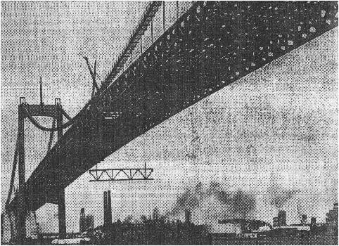
This 1957 photo shows the last of the roadway trusses being hoisted onto the Walt Whitman Bridge. (Photo by Bethlehem Steel Corporation, from the Philadelphia Inquirer archives.)
|
|
|
|
|
|
|
|
|
|
|
|
|
|
|
|
|
|
|
|
|
|
A NEW DELAWARE RIVER BRIDGE: By the early 1950s, the Philadelphia City Planning Commission finalized the route of the bridge and its expressway approaches. Connecting the proposed Schuylkill Expressway with the North-South Freeway, a new route being developed by the New Jersey State Highway Department, the Philadelphia-Gloucester Bridge (as it was then called) was to also alleviate congestion on the Benjamin Franklin Bridge, which was carrying more than 75,000 vehicles per day, four miles to the north.
|
|
|
|
|
|
|
|
|
|
|
|
|
|
|
The new Delaware River Port Authority (DRPA), a new bi-state agency comprised of Pennsylvania and New Jersey officials, was charged with the construction and maintenance of the proposed crossing. From the beginning, the DRPA proposed a seven-lane bridge for the South Philadelphia-Gloucester crossing. The bridge plan was opposed by the mayors of Gloucester City and Camden, who contended that their four-lane tunnel alternative would require fewer right-of-way acquisitions, and would not blight the surrounding area like the bridge alternative would.
|
|
|
|
|
|
|
|
|
|
|
|
|
|
|
|
|
|
Meanwhile, the DRPA defended its plan, stating that the bridge alternative would handle more traffic, cost $24 million less and take one less year for construction than would the tunnel alternative. In August 1952, the DRPA received permission from the Army Corps of Engineers to construct the bridge.
The new crossing was to be called the Walt Whitman Bridge, after the nineteenth-century poet and author of Leaves of Grass (which was hailed as the "Declaration of Independence of American letters") who spent the last 19 years of his life in nearby Camden. The naming of the bridge itself was a subject of controversy. While the span was still under construction, the Catholic Diocese of Camden and local officials in South Jersey led a letter-writing campaign against the naming of the bridge after Whitman because of his homosexuality.
|
|
|
|
|
|
|
|
|
|
|
|
|
|
|
 |
|
|
|
|
|
|
|
|
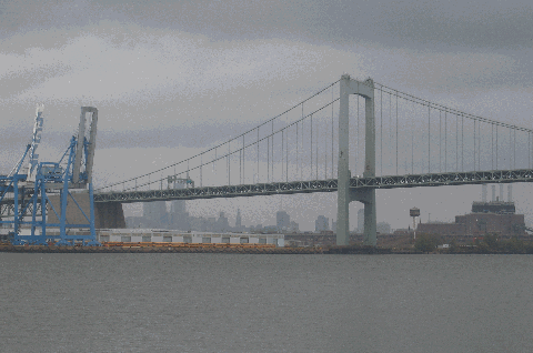
This 2007 photo shows the Walt Whitman Bridge (I-76) from Gloucester City, New Jersey looking northwest toward Center City Philadelphia. (Photo by Steve Anderson.)
|
|
|
|
|
|
|
|
|
|
|
|
|
|
|
|
|
|
|
|
|
|
|
|
|
|
|
|
|
|
DESIGN AND CONSTRUCTION: One of the last bridges designed by Othmar Ammann, the Walt Whitman Bridge held true to the design standards, such as deep stiffening trusses and streamlined towers, that characterized his other postwar works including the Delaware Memorial Bridge (opened in 1951), the Throgs Neck Bridge (opened in 1961) and the Verrazano-Narrows Bridge (opened in 1964).
|
|
|
|
|
|
|
|
|
|
|
|
|
|
Test borings for the bridge began in September 1952. However, due to delays caused by material shortages during the Korean War, construction of the bridge did not begin until August 1953. Concrete anchorages were dug 60 feet deep on both sides of the Delaware River. Each anchorage measured 200 feet long, 120 feet wide and 130 feet above the ground. The tower piers, which each measured 174 feet by 64 feet, were dug 100 feet below the river on the Philadelphia side, and 80 feet into the river on the New Jersey side.
By mid-1954, work on the two 378-foot-tall towers began. The towers, which required 10,215 tons of structural steel, support the bridge's 2,000-foot-long main span and two 770-foot-long side spans. Portions of the towers were pre-assembled after fabrication at the Bethlehem Steel plant in Pottstown, Pennsylvania.
In early 1955, work began on spinning the bridge's 3,845-foot-long main cables and suspenders. The two main cables are each 23-1/8 inches in diameter, and an estimated 60,000 miles of 0.2-inch-diameter wire was used in their creation. Together, the cables support the bridge's roadway 150 feet above the Delaware River at midspan.
Construction of the roadway and approaches began in early 1956. Designed for the expressway era of the 1950's, the roadway was built with seven 11-foot-wide lanes that provided flexibility during rush-hour periods. Construction of the roadway required 11,733 tons of structural steel. The Philadelphia approach consists of three deck truss spans (measuring west from the anchorage 245 feet, 356 feet and 245 feet), followed by 35 girder beam spans of varying length. This approach required the partial relocation of a nearby railroad yard. The New Jersey approach consists of six deck truss spans (measuring east from the anchorage, three spans of 260 feet, followed by three spans of 180 feet), followed by nine girder spans of varying length. This approach required the relocation of Newton Creek, and the filling of the old creek bed and other depressed areas.
The final stages of construction were delayed by a prolonged steel strike. On August 15, 1957, the governors of Pennsylvania and New Jersey dedicated the bridge, and one day later, the DRPA opened the bridge to traffic. The four-year-long project cost $90 million and eight lives. The American Institute of Steel Construction bestowed on the Walt Whitman Bridge the honor of "Most Beautiful Structure of Steel of 1957."
ONE OF THE FIRST BRIDGES OF THE INTERSTATE ERA: In 1956, while it was still under construction, the bridge became part of the Interstate highway network. When the bridge opened in 1957, motorists - for a 25-cent-toll - were provided a true expressway bypass of Center City Philadelphia.
The bridge changed Interstate designations several times during the ensuing years:
June 1958-October 1958: I-280; Pennsylvania officials proposed this designation to correspond with the commonwealth's proposed Interstate segments.
October 1958-November 1958: I-380; New Jersey officials suggested this designation to correspond with that state's proposed Interstate segments.
November 1958-early 1964: I-680; this was the final designation given by the American Association of State Highway Officials (AASHO).
1964-1973: I-676; approved by AASHO upon the re-designation of the easternmost section of the Schuylkill Expressway from I-680 to I-676.
1973-present: I-76; upon re-designation of the entire length of the Schuylkill Expressway to I-76.
To the west, the bridge connects to the Schuylkill Expressway (I-76) and the Delaware Expressway (I-95). To the east, the bridge connects to the North-South Freeway (I-76, I-676, and NJ 42) and US 130.
|
|
|
|
|
|
|
|
|
|
|
|
|
|
|
 |
|
|
|
|
|
|
|
|
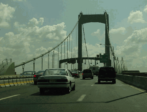
This 2002 photo shows the eastbound Walt Whitman Bridge (I-76) at the South Philadelphia anchorage. Note the moveable concrete median "zipper" barrier. (Photo by Jim K. Georges.)
|
|
|
|
|
|
|
|
|
|
|
|
|
|
|
|
|
|
|
|
THE BRIDGE TODAY: The Walt Whitman Bridge, whose main suspension span is the 27th longest in the world, currently carries approximately 120,000 vehicles (AADT) across the Delaware River each day. On summer weekends, the bridge carries as many as 150,000 vehicles per day. One-way toll collection began on the bridge in 1992, and in 1999, the bridge joined the EZ-Pass regional toll collection network.
|
|
|
|
|
|
|
|
|
|
|
|
|
|
To improve safety, the DRPA replaced the temporary barrier with a permanent concrete "zipper" barrier on the bridge roadway during the fall of 2000. The barrier, which is hinged every three feet, enables a machine called a "barrier carrier" to shift the divider from one lane to another. With the barrier, roadway capacity can be optimized: four lanes in the peak direction, three lanes in the off-peak direction. The barrier can shift when a lane is taken out of service for maintenance.
RECONSTRUCTION EFFORTS: Beginning in 1994 and continuing for another five years, the Walt Whitman Bridge underwent its first major rehabilitation. The $130 million project included widening and repairing the decks, replacing the deck slab on the approaches, installing an auxiliary support system at the hanger pin locations, inspecting for structural fatigue, and rehabilitating the bridge to comply with current seismic engineering codes. The three-inch concrete deck installed in the 1990's consisted of epoxy-coated steel and a special concrete that reacts to changing weather conditions, and was simply overlaid on the old deck (which was comprised of simple steel-reinforced concrete topped by one inch of concrete.) The main roadway was widened from 79 feet to 83 feet, allowing for (approximately) seven 12-foot-wide lanes across the Delaware River.
In July 2007, shortly after the Walt Whitman Bridge celebrated its half-century birthday, the DRPA announced plans for a $100 million rehabilitation that would replace the bridge's existing deck with a lightweight orthotropic deck. The new deck, which would weigh 5,000 tons less than the old one (mostly because of the thinner layer of concrete), would be replaced one lane at a time. A scale model of the deck would be tested in a wind tunnel prior to reconstruction. As in the 1994-1999 project, six of the bridge's seven lanes would be kept open to traffic. Construction is scheduled to begin at the end of 2008, with completion slated three years hence.
Future improvements to the bridge may include decorative night lighting similar to that found on the Benjamin Franklin Bridge, but DRPA chief John Matheussen said the redecking project was his first priority.
|
|
|
|
|
|
|
|
|
|
|
|
|
|
 |
|
|
|
|
|
|
|
|
|
|
|
|
|
|
|
|
|
|
|
 |
|
|
|
 |
|
|
|
|
|
SOURCES: "Philadelphia Expressway Program," Philadelphia City Planning Commission (1947); "Gloucester Span Would Link Roads," The Courier-Post (11/29/1948); "Schuylkill Expressway, Roosevelt Boulevard Expressway and Vine Street Expressway," Philadelphia City Planning Commission (1950); "Fight for South Jersey-Pennsylvania Project Began in 1926, Now Nears Climax" by Joseph S. Wells, The Courier-Post (5/26/1952); "Delaware Agency To Start New Span," The New York Times (8/03/1952); "The Delaware Valley Moves Ahead," Delaware River Port Authority (1953); "Philadelphia's New Shore Route" by William G. Weart, The New York Times (4/01/1957); "It's a New Shore Route for 25 Cents" by William A. Forsythe, The Philadelphia Evening Bulletin (5/12/1957); "Walt Whitman Bridge: Aid to Traffic-Tangled Woes" by Frank Rosen, The Philadelphia Inquirer (5/15/1957); "Bridge Is Opened at Philadelphia" by William G. Weart, The New York Times (5/16/1957); "New Roads with New Numbers Will Parallel Old U.S. Routes" by George Cable Wright, The New York Times (9/19/1958); "The Walt Whitman Bridge," Delaware River Port Authority (1958); "Philadelphia Road Link Opened," The New York Times (6/28/1959); "It's About To Get Messy on Whitman Bridge" by Larry Fish, The Philadelphia Inquirer (8/31/1994); "Lane by Lane, Span Is Renewed" by Joseph A. Gambardello, The Philadelphia Inquirer (12/20/1998); "Bridge Overhaul on Deck" by Edward Calimore, The Philadelphia Inquirer (7/26/2007); Modjeski and Masters; New Jersey Department of Transportation; Philadelphia Interactive; Jeff Kitsko; Scott Kozel; Raymond C. Martin; Alex Nitzman; Brian Polidoro; Sandy Smith; Stephen Summers; Alexander Svirsky; Jeff Taylor; Stéphane Theroux; Rush Wickes.
I-76 shield by Ralph Herman.
Walt Whitman Bridge shield by Delaware River Port Authority.
Lightposts by Millerbernd Manufacturing Company.
|
|
|
|
|
|
|
|
|
|
|
|
|
|
|
|
 |
|
 |
|
|
|
|
|
|
|
|
|
|
|
|
|
|
|
|
|
|
|
|
|
|
 |
|
|
|
|
|
|
|
|
|
 |
|
|
|
|
|
|
|
|
 |
|
|
|
|
|
|
|
|
|
|
|
|
Site contents © by Eastern Roads. This is not an official site run by a government agency. Recommendations provided on this site are strictly those of the author and contributors, not of any government or corporate entity.
|
|
|
|
|
|
|
|
|
|