 |
|
|
|
|
|
|
|
|
|
|
|
|
|
|
|
|
|
|
|
|
|
|
|
|
|
|
|
|
|
|
|
|
|
|
|
|
|
|
|
|
|
|
|
|
|
|
|
|
|
|
|
|
|
|
|
|
|
|
|
|
|
|
|
|
|
|
|
|
|
|
|
|
|
|
|
|
|
|
|
|
|
|
|
|
 |
|
|
|
|
 |
|
 |
|
|
|
|
|
|
|
|
|
|
|
|
|
|
|
|
 |
|
|
|
|
|
|
|
|
|
|
|
|
|
|
|
 |
|
|
|
|
|
|
|
|
|
|
|
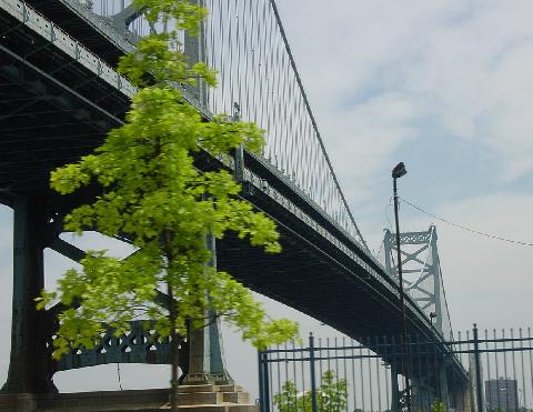
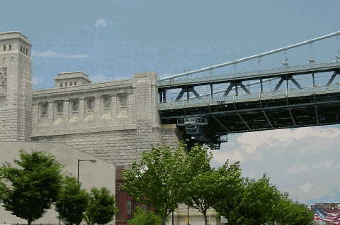
This 2002 photo shows the Benjamin Franklin Bridge (I-676 and US 30) from Penn's Landing, looking east toward Camden. (Photo by Jim K. Georges.)
|
|
|
|
|
|
|
|
|
 |
|
|
|
|
 |
|
|
|
|
|
|
|
|
Type of bridge:
Construction started:
Opened to traffic:
Length of main span:
Length of each side span:
Length, anchorage to anchorage:
Total length of bridge and approaches:
Width of bridge:
Width of roadway:
Number of traffic lanes:
Number of rapid transit tracks:
Height of towers above mean high water:
Clearance at center above mean high water:
Deepest foundation below mean high water:
Masonry used in anchorages:
Total masonry used in bridge and approaches:
Steel used in towers and suspended structure:
Weight suspended from cables:
Total weight of bridge:
Number of cables:
Diameter of each of two cables:
Total number of wires per cable:
Foundation type:
Cost of original structure:
|
|
|
|
|
|
|
|
|
Suspension
January 6, 1922
July 1, 1926
1,750 feet (533.4 meters)
892 feet (271.9 meters)
3,536 feet (1,077.8 meters)
9,573 feet (2,917.9 meters)
128 feet (39.0 meters)
78 feet (23.8 meters)
7 lanes
2 tracks
385 feet (117.3 meters)
135 feet (41.1 meters)
170 feet (51.8 meters)
216,000 cubic yards (165,144 cubic meters)
318,000 cubic yards (243,128 cubic meters)
61,700 tons (55,973 metric tons)
38,400 tons (34,836 metric tons)
720,000 tons (653,173 metric tons)
2 cables
30 inches (76.2 centimeters)
18,666 wires
Caisson
$45,200,000
|
|
|
|
|
|
|
|
|
|
|
 |
|
|
|
|
|
|
|
|
Passenger car cash toll (westbound only):
Passenger car EZ-Pass toll (westbound only):
|
|
|
|
|
|
|
|
|
$5.00
$5.00
(Commuter discounts available for New Jersey motorists)
|
|
|
|
|
|
|
|
|
|
|
|
|
|
|
|
|
|
|
|
 |
|
|
|
|
|
EARLY PLANS FOR A DELAWARE RIVER CROSSING: Like New York City, Philadelphia waited more than a century for a fixed crossing to New Jersey. The first plan for a Delaware River bridge between Philadelphia and Camden was developed in 1818, when the proposed "Farrand and Sharp's Bridge" called for a low-level, multi-span structure with several openings to permit passage by tall ships. This early plan was followed in the 1840s by two separate plans for suspension bridges. However, none of the nineteenth-century proposals attracted serious interest.
|
|
|
|
|
|
|
|
|
|
|
|
|
|
It took the introduction of the automobile to resurrect interest in the proposed Delaware River bridge. In 1913, the city of Philadelphia formed the Penn Memorial Bridge Committee to study a possible fixed crossing.
The desire for a bridge over the Delaware River was long held not only by Philadelphians, but also by New Jersey farmers who wished to transport their produce to Pennsylvania markets. Between 1908 and 1911, the state of New Jersey passed laws stipulating that three or more counties could join to initiate a bridge study if all three counties were contiguous, and at least one bordered the river to be crossed. Influenced by the agricultural interests, Gloucester, Camden, and Burlington counties eventually came up with the funds to study the proposed Delaware River Bridge.
In 1918, the states of Pennsylvania and New Jersey established commissions for a Delaware River span, and hired the firm of Waddell and Son to make a consulting-engineering study. The report recommended that a suspension span be constructed from Vine Street and Race Street in Philadelphia, to Linden Street in Camden. It also recommended helical incline approaches because of the high cost of land.
On December 12, 1919, the Delaware River Bridge Joint Commission was established. The Joint Commission appointed Rudolphe Modjeski, the chief engineer who oversaw the completion of the Manhattan Bridge, as chief bridge engineer. The Commission adopted the location proposed by Waddell and Son, but rejected the helical approach design in favor of a more conventional one.
The next major decision concerned the construction of either a suspension or a cantilever span across the Delaware River. For the suspension bridge design, the main span was to be 1,750 feet, flanked by side spans of 719½ feet. For the cantilever bridge design, the main span was also to be 1,750 feet, but was to be flanked by shorter side spans of 500 feet. Both bridges were to have mid-span clearances of 135 feet over mean high water. By 1922, Modjeski's suspension design was approved by the Delaware River Bridge Joint Commission.
CONSTRUCTING THE BRIDGE: Physical construction of the Delaware River Bridge began on January 6, 1922, but "in lieu of the traditional digging of the first spadeful of dirt, a plank was torn loose" from a pier that the bridge would replace.
For his Delaware River Bridge design, Modjeski employed a practical application of "deflection theory" similar to the design found on the Manhattan Bridge. Developed by Leon Moisseiff, a former design engineer with the New York City Bridge Department who offered his services for the new Philadelphia span, deflection theory stated that there are three opposing forces on the deck and suspension cables as follows:
one downward force caused by the load of the roadway
one force in one part of the cable, pulling up and to the left
one force in the other part of the cable, pulling up and to the right
As was common with bridges of the day, deep stiffening trusses were incorporated into the design of the bridge. These trusses were placed above the main roadway deck. Together with the two main cables, the stiffened deck could support a load of 60,000 tons.
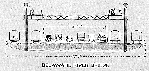
The main roadway originally accommodated six lanes for vehicular traffic and two streetcar tracks. (The streetcar tracks were soon converted into two additional vehicular lanes.) Two rapid transit tracks were constructed on outboard structures on either side of the roadway, but were left unused when the bridge opened. Above the rapid transit tracks were two pedestrian walkways.
|
|
|
|
|
|
|
|
|
|
|
|
|
|
|
|
|
Modjeski also designed two 385-foot-high steel towers, the design of which was derided by fellow bridge designed Gustav Lindenthal. Lindenthal said that the steel towers were crafted "too much on the utilitarian principle of braced telephone poles or derricks, holding up ropes." However, he acknowledged that these towers were lighter and cheaper than comparable stone towers, thereby requiring not only less costly and time-consuming foundations, but also less capital investment.
|
|
|
|
|
|
|
|
|
|
|
|
|
|
|
|
|
|
|
|
|
The anchorages on either side give the bridge an appearance of massiveness. Each of the granite anchorages to which the steel cables are attached covers three-quarters of an acre. The two anchorages, which together required 216,000 tons of masonry, rise 175 feet above the ground. Their "toeholds" sink into the earth 65 feet into the Philadelphia side, and 105 feet into the Camden side. On the western anchorage are carved the seals of the state of Pennsylvania and the city of Philadelphia, and on the eastern anchorage are carved the seals of the state of New Jersey and the city of Camden.
The entrances to the bridge also exhibited grandeur. Four bronze "winged victory" statues - two statues adorning the Philadelphia and Camden plaza portals - were erected.
|
|
|
|
|
|
|
|
|
 |
|
|
|
|
 |
|
 |
|
|
|
|
|
|
|
|
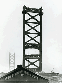
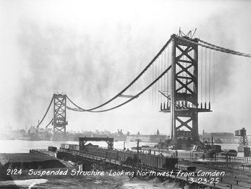
LEFT: This 1924 photo shows the towers of the Benjamin Franklin Bridge under construction from the Philadelphia shoreline. (Photo by Delaware River Port Authority.) RIGHT: This 1925 photo shows the initial construction of the suspenders and roadway on the bridge. (Photo by George Wonfor via AAA Mid-Atlantic.)
|
|
|
|
|
|
|
|
|
|
|
|
|
|
|
|
|
|
|
|
TOLL CONTROVERSY DIVIDES PENNSYLVANIA AND NEW JERSEY: Just before the Delaware River Bridge opened, a controversy erupted between the states of New Jersey and Pennsylvania over the issue of charging tolls on the bridge. Pennsylvania officials wanted a free bridge paid for by taxes. On the other hand, officials in New Jersey wanted tolls on the new bridge, citing that while it would cost motorists to cross the Holland Tunnel (which was also under construction at the time) into New York City, it would cost nothing to cross the new bridge into Philadelphia.
|
|
|
|
|
|
|
|
|
|
|
|
|
|
The crisis became so severe that there were even proposals to tear down the bridge until the toll controversy was resolved. Work on the bridge stopped for some time until the matter was settled. Unfortunately, the work stopped just before the covering of the cables.
In late 1925, the U.S. Supreme Court granted permission for Pennsylvania to sue New Jersey over this issue. The U.S. Supreme Court told both states that they would have six months to settle the problem on their own.
However, sentiment among Pennsylvania officials soon shifted after the following comments appeared in Engineering News-Record:
Under the pressure of postwar costs and overdue public needs, taxation has largely ceased to be an attractive means of financing large public improvements
If the outcome of Pennsylvania's attempt to outwit the New Jersey taxpayer succeeds, future public toll-bridge proposals will not have an easy time of it.
Ultimately, the toll controversy was not resolved through the courts, the press or the public. Rather, information had been leaked from Philadelphia City Hall that money that was appropriated for the project by the commonwealth of Pennsylvania was being skimmed by the powerful Vare political organization. Long after the contracts went out, the oldest brother in the Vare family had offered contracts to his friends and family. When this information had been disclosed, the Pennsylvania State Legislature immediately removed the Vare organization from the contracts, and compromise with the state of New Jersey to construct tollbooths. One week after the story broke, work resumed to complete the bridge.
THE BRIDGE OPENS, AND SPAWNS A NEW ERA: When the Delaware River Bridge opened to traffic on July 1, 1926, in time for the nation's sesquicentennial, it claimed the longest main suspension span. It was an instant success, attracting the 35,000 vehicles a day that paid 25 cents to cross the Delaware River. During its first three moths in operation, the bridge carried two million vehicles, twice the amount of vehicles forecast for that period. With traffic volumes continuing to grow through the late 1920s, officials suggested adding two additional traffic lanes in each direction by utilizing the then-unused outboard structures. The proposal, which would have brought vehicular capacity to ten lanes, never made it past the discussion stage.
While it lost its main span title to the George Washington Bridge in 1931, the Benjamin Franklin Bridge spawned a new era of long-span suspension bridge construction that lasted through the late 1930s.
|
|
|
|
|
|
|
|
|
|
|
|
|
|
|
 |
|
|
|
|
|
|
|
|
Original cross-section of the roadway on the Benjamin Franklin Bridge. (Figure by Paul Phillipe Cret and Rudolphe Modjeski.)
|
|
|
|
|
|
|
|
|
|
|
|
|
|
|
|
|
|
|
|
ADAPTING TO THE INTERSTATE ERA: In 1951, the Delaware River Port Authority (DRPA) was established by the states of Pennsylvania and New Jersey. The new bi-state commission was to oversee improvements to the Delaware River Bridge (now renamed the Benjamin Franklin Bridge, after one of the "Founding Fathers") and construct new crossings over the Delaware River.
|
|
|
|
|
|
|
|
|
|
|
|
|
|
One of the first projects that the agency oversaw was a reconfiguration of the deck. To accommodate the wider vehicles of the postwar era, an undivided seven-lane roadway was opened to traffic. By the mid-1950s, as daily traffic counts exceeded 75,000 vehicles per day, the DRPA authorized construction of a new suspension span four miles to the south between South Philadelphia and Gloucester City, New Jersey.
In 1956, the Benjamin Franklin Bridge, which kept the US 30 designation, became part of the Interstate highway system. The bridge changed Interstate designations several times during the ensuing years:
June 1958: I-895; Pennsylvania officials proposed this designation to correspond with the commonwealth's proposed Interstate segments.
October 1958: I-380; New Jersey officials suggested this designation to correspond with that state's proposed Interstate segments.
November 1958-early 1964: I-80S; this was the final designation given by the American Association of State Highway Officials (AASHO).
1964-1973: I-76; approved by AASHO upon the re-designation of the Vine Street Expressway, Schuylkill Expressway and the Pennsylvania Turnpike from I-80S to I-76.
1973-present: I-676; upon re-designation of the Vine Street Expressway from I-76 to I-676.
The bridge, which was tied to the North-South Freeway (I-676) in 1980 and the Vine Street Expressway (I-676) in 1991, underwent substantial rehabilitation and modernization during the 1980's.
However, is the Benjamin Franklin Bridge really an Interstate? Both the DRPA and the New Jersey Department of Transportation (NJDOT) consider the bridge part of I-676, but the Pennsylvania Department of Transportation (PennDOT) does not. Chris Blaney, New Jersey contributor to phillyroads.com and misc.transport.road, made the argument that the bridge is not up to Interstate standards as follows:
The Ben Franklin Bridge is not Interstate standard at all. The bridge has seven undivided lanes, without even cones to separate opposing traffic flows as there are on other undivided bridges. The approaches are not even Interstate standard. On the Philadelphia side, there are traffic lights at the approaches, while the non-stop ramps from the Vine Street Expressway (I-676) to only to the Delaware Expressway (I-95), not to the bridge itself. In the eyes of PennDOT, you have to exit I-676 itself to get onto the bridge. On the New Jersey side, there are cross streets at the approach, but unlike on the Holland Tunnel Approach (I-78), there are no traffic lights.
The official Pennsylvania highway map shows the Benjamin Franklin Bridge as US 30 only, not as I-676. (They do not use the blue Interstate color as the highway line.) For its maps, Rand McNally uses their thick orange line denoting a "four-lane divided highway" for the New Jersey approach, not the freeway blue color. (The bridge itself is shown as the green toll highway color on the maps.)
In order to justify full Interstate status on the Ben Franklin Bridge, the approaches would have to be brought up to full Interstate standards. With the way things are in that area, that is not likely to happen. However, I would not object to the DRPA using "TO I-676" signs all over the place since the bridge does serve to make I-676 a continuous route, although US 30 also does the same thing.
For the sake of continuity, PennDOT and the NJDOT show both I-676 and US 30 shields on guide signs leading to the Benjamin Franklin Bridge.
|
|
|
|
|
|
|
|
|
|
|
|
|
|
|
 |
|
|
|
|
|
|
|
|
This 2002 photo shows a close-up of the Philadelphia anchorage on the Benjamin Franklin Bridge. (Photo by Jim K. Georges.)
|
|
|
|
|
|
|
|
|
|
|
|
|
|
|
|
|
|
|
|
|
|
|
|
|
|
|
|
|
|
RAIL SERVICE ON THE BEN FRANKLIN BRIDGE: Sandy Smith, Philadelphia contributor to phillyroads.com and misc.transport.road, submitted the following about the original mass transit scheme on the Benjamin Franklin Bridge:
The two tracks inboard of the bridge's deck trusses were intended to carry the cars of the Public Service-Camden system across the river to an underground terminal beneath the west entrance plaza. One poster on the phl.transportation newsgroup claimed that there were to be two intermediate car stops on the bridge itself, with elevators built into anchorages to serve them. The tracks were apparently never used, and by 1932, the Public Service-Camden system abandoned its streetcar system in favor of buses.
|
|
|
|
|
|
|
|
|
|
|
|
|
|
For years after the Benjamin Franklin Bridge opened, the outboard structures that were to be used for rail service sat unused. Rail service between Philadelphia and Camden became a reality in 1936, when new service began over the bridge under the auspices of the Delaware River Joint Commission. The new service ran from 8th and Market streets in Center City Philadelphia to the Broadway station in downtown Camden. Through service from Girard Avenue via the Broad Street Spur / Ridge Avenue subway line began soon thereafter.
Soon after the DRPA was organized in 1951, numerous studies were conducted on implementing rail service between the Philadelphia-Camden area and the South Jersey suburbs. By the early 1960's, the DRPA had narrowed its selection to the following two proposals:
The engineering firm Parsons Brinckerhoff recommended the construction of a three-corridor system that would proceed through a new tunnel under the Delaware River. The northern corridor would extend to Moorestown, the central corridor to Lindenwold, and the southern corridor to Glassboro. The estimated cost for this system was $242 million.
The engineering firm Louis T. Klauder and Associates recommended utilizing the existing rail line on the Benjamin Franklin Bridge and subway connections to Philadelphia instead of building a new tunnel, at a cost of $94 million. Since the highest concentration of riders would be in the central corridor, the Klauder report recommended that this line be constructed first.
The DRPA finally selected the Klauder alternative in 1963. One year later, the agency broke ground for the new PATCO rail system, and on February 15, 1969, the first trains rolled on the 14.2-mile-long system between Center City Philadelphia and Lindenwold, New Jersey.
The underground terminal at Franklin Square, beneath the west entrance plaza, had been open and closed several times since the 1930s, but was permanently closed and sealed in 1979 due to low patronage and concerns about crime and homelessness.
STANDING UP TO THE WORST: During the past decade, the structural integrity of the Benjamin Franklin Bridge was put to the test. In December 1992, the steeple of historic St. Augustine's Church blew onto the main roadway of the bridge during a nor'easter, closing the span for three days. In September 1998, a worker's carelessly discarded cigarette ignited a fire in the south suspension cable, closing the span for four hours in the height of the evening rush. In both cases, no one was hurt, and no significant structural damage was found.
|
|
|
|
|
|
|
|
|
|
|
|
|
|
|
 |
|
|
|
|
|
|
|
|
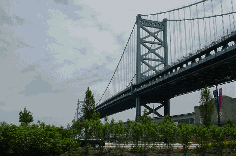
This 2002 photo shows the Benjamin Franklin Bridge (I-676 and US 30) looking east from Penn's Landing toward Camden. (Photo by Jim K. Georges.)
|
|
|
|
|
|
|
|
|
|
|
|
|
|
|
|
|
|
|
|
BRINGING A LANDMARK SPAN INTO THE FUTURE: The Benjamin Franklin Bridge, whose main suspension span is the 34th longest in the world, today carries an average of 100,000 vehicles (AADT), and more than 40,000 rail commuters (via the PATCO system) across the Delaware River each day.
To commemorate the bicentennial of the signing of the Constitution, a new lighting system was unveiled on in 1987. Designed by Venturi, Scott Brown and Associates, the new lighting system employs an innovative technology that allows the lights on the main suspension cables to be switched on and off rapidly in sequence. This sequence is triggered by the passage of the PATCO commuter trains over the bridge. Later, the DRPA added a new decorative lighting system to illuminate the 385-foot-tall steel towers and the stone anchorages.
|
|
|
|
|
|
|
|
|
|
|
|
|
|
In recent years, the DRPA has embarked on the following capital improvements to the Benjamin Franklin Bridge:
In October 1992, one-way toll collection began on the westbound lanes, leaving the eastbound direction toll-free. On December 18, 1999, the Benjamin Franklin Bridge joined the EZ-Pass regional toll collection network.
To improve safety, the DRPA installed a movable concrete "zipper" barrier on the bridge roadway during the fall of 2000. The barrier, which is hinged every three feet, enables a machine called a "barrier carrier" to shift the divider from one lane to another. With the barrier, roadway capacity can be optimized: four lanes in the peak direction, three lanes in the off-peak direction. The barrier can shift when a lane is taken out of service for maintenance.
Beginning in 2000, the DRPA began a seven-year, $92 million project to strip nearly 75 years of paint from the bridge and repaint the span in its trademark "Benjamin Franklin Blue." In the past, workers simply painted over previous coats on the bridge's five million square feet of steel structure. In recent years, however, the layers have become so thick that they have pulled away from the original surface. During the ongoing project, the DRPA is keeping either the north walkway or the south walkway - but not both - open to pedestrians and cyclists each day from 6:00 AM to 7:00 PM. (At the present time, only the north walkway is open.)
THE BRIDGE CELEBRATES 75 YEARS: On July 1, 2001, the DRPA celebrated the 75th anniversary of the Benjamin Franklin Bridge by closing the span to all but pedestrian traffic. Tens of thousands of people - some in 1920s attire - crossed the span to the diamond anniversary ceremonies.
Len Pundt, frequent contributor to phillyroads.com, recalled the ceremonies as follows:
I arrived at the bridge at about 6:00 AM. I thought I'd be one of maybe a few hundred there that early, but there were already thousands. The wait for the anchorage tours was already an hour and 15 minutes. From the Camden approach, I walked up the bridge's north walkway to the line for the anchorage tours.
As you know the anchorages were designed to contain trolley stations, but were never used for that purpose. We entered the anchorage from the walkway level. Above the doorways for stairs and elevators were terra cotta panels depicting the progress of transportation. All the interiors are decorated with three-inch-wide blue-and-cream terra cotta tiles, with a "wavy water" motif where the walls meet the ceiling.
We descended a stairway (passing outboard of the rail line) to one level below the roadway. On that level is a passageway that passes beneath the rail line and roadway from one side of the anchorage to the other. Stairs descend from an area beside the roadway (inboard of the pylons) to this level. (The area beside the roadway was intended as the trolley stop.) Also on this level, below the roadway, is where there are stalls intended for merchants. (As you know, the trains are, and were, on the roadway level outboard of the pylons; the trolleys would have been on the outer edge of the roadway, just inboard of the pylons.) Travelers would have entered via the walkway, descended two levels (passing outboard of, then under the train tracks), walk inboard a short distance (where they would encounter the vendors), then walk up one level to the trolley.
From the level beneath the roadway, where the vendors would have been, the tourists entered a doorway on either side of the bridge where we could view the cables coming down and splaying apart into the actual anchorages. Going back to the roadway level, we were directed up the stairs on the south side to the once-intended trolley stop at the level of the roadway. This area is outboard of the edge of the roadway (where the trolley tracks would have been) between the main part of the anchorage and the point where the main cable descends below the roadway level (between the train tracks and the area for trolley tracks).
On the roadway, there were antique vehicles (about thirty cars and trucks) and antique fire engines. On the de-energized south tracks, at mid-span, there were two of the original rail cars that ran in the 1930s. On the roadway, the John Coltrane jazz band played all morning.
After the bridge walk and anchorage tour, officials re-dedicated the four "winged victory" statues that prior to 1949 adorned the Philadelphia and Camden plazas. (The statues were placed into underground storage prior to the widening of the bridge.) The four statues will become part of the DRPA Delaware River aerial tram now under construction that will connect Penn's Landing with the revitalized Camden waterfront.
|
|
|
|
|
|
|
|
|
|
|
|
|
|
|
 |
|
|
|
|
|
|
|
|
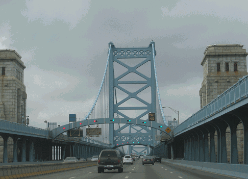
This 2007 photo shows the westbound Benjamin Franklin Bridge at the Camden anchorage. The granite portals rise above the roadway, giving the bridge an appearance of massiveness. (Photo by Steve Anderson.)
|
|
|
|
|
|
|
|
|
|
|
|
|
|
 |
|
|
|
|
|
The design of the Benjamin Franklin Bridge is similar to that of the Manhattan Bridge in that both crossings were designed using "deflection theory." Over the years, heavy subway traffic on the outboard structures has caused twisting of the deck and stress on the main cables. Maximum torsion occurs when subway trains start to cross opposite sides of the bridge at the same time.
|
|
|
|
|
|
|
|
|
|
|
|
|
|
|
To maintain the structural integrity of the Benjamin Franklin Bridge, the PATCO tracks should be removed. New tunnels should be constructed under the Delaware River to better handle not only the existing PATCO Lindenwold service, but also new trains from the proposed PATCO Moorestown and Glassboro lines.
|
|
|
|
|
|
|
|
|
 |
|
|
|
|
|
|
|
|
|
 |
|
|
|
 |
|
|
|
|
|
SOURCES: "Camden Bridge Ready for Work," The New York Times (7/01/1926); "Traffic Volume on the Delaware Bridge," The Philadelphia Inquirer (10/13/1926); "Four More Traffic Lanes Asked for River Bridge," The Philadelphia Inquirer (12/21/1929); "Schuylkill Expressway, Roosevelt Boulevard Expressway and Vine Street Expressway," Philadelphia City Planning Commission (1950); "New Roads with New Numbers Will Parallel Old U.S. Routes" by George Cable Wright, The New York Times (9/19/1958); "Interstate 676: Administrative Action Final Environmental Impact Statement and Section 4(f) Statement," Federal Highway Administration and New Jersey Department of Transportation (1976); "Interstate 676, Vine Street Expressway: Administrative Action Draft Environmental Impact Statement and Section 4(f) Statement," Federal Highway Administration and Pennsylvania Department of Transportation (1977); Great American Bridges and Dams by Donald C. Jackson, Preservation Press-John Wiley and Sons (1988);"A Green Light for Highway" by Laurie Hollman, The Philadelphia Inquirer (1/06/1991); Engineers of Dreams by Henry Petroski, Vintage Books-Random House (1995); "Fire Shuts Benjamin Franklin Bridge" by Thomas J. Gibbons Jr. and Larry Fish, The Philadelphia Inquirer (9/30/1998); "Agency Approves Benjamin Franklin Bridge Repainting" by Joseph A. Gambardello, The Philadelphia Inquirer (1/27/2000); "'Winged Victory' Makes a Comeback," Philadelphia Business Journal (9/08/2000); "It's a Grand Old Bridge" by Joseph A. Gambardello, The Philadelphia Inquirer (6/29/2001); "A Twice in a Lifetime Experience" by Marc Schogol, The Philadelphia Inquirer (7/02/2001); "Thousands Celebrate Ben Franklin Bridge's 75th" by Ed Sholinsky, The Salem County Record (7/06/2001); "The Subways, Railways and Stations of Philly" by Harry Kyriakodis (2001); Delaware River Port Authority; Independence Hall Association; New Jersey Department of Transportation; Philadelphia Interactive; Venturi, Scott Brown and Associates; Chris Blaney; Rich Cionci; Peggy Darlington; Tom Fekete; Nick Klissas; Scott Kozel; Raymond C. Martin; Alex Nitzman; Scott Oglesby; Len Pundt; Sandy Smith; Christof Spieler; Stephen Summers; Jeff Taylor; Stéphane Theroux; Rush Wickes.
I-676 and US 30 shields by Ralph Herman.
Benjamin Franklin Bridge shield by Delaware River Port Authority.
Lightposts by Millerbernd Manufacturing Company.
|
|
|
|
|
|
|
|
|
|
|
|
|
|
|
|
 |
|
 |
|
 |
|
|
|
|
|
|
|
|
|
|
|
|
|
|
|
|
|
|
|
|
|
|
|
|
 |
|
|
|
|
|
|
|
|
|
 |
|
|
|
|
|
|
|
|
 |
|
|
|
|
|
|
|
|
|
|
|
|
Site contents © by Eastern Roads. This is not an official site run by a government agency. Recommendations provided on this site are strictly those of the author and contributors, not of any government or corporate entity.
|
|
|
|
|
|
|
|
|
|