
|
This 2001 photo shows the northbound I-676 at EXIT 1 (Collings Avenue). (Photo by Andy Field and Alex Nitzman.) |
||

|
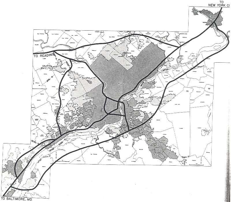
PLANNED AS A PARKWAY: In 1932, the Regional Planning Federation (the predecessor agency to the Delaware Valley Regional Planning Commission) proposed a parkway system around the Philadelphia area similar to that constructed by Robert Moses. Like the Moses parkways in New York, the four-lane parkways were to feature controlled access, stone-arch bridges, timber lightposts and natural vegetation. |
||
|
The plan proposed a parkway extending from the Benjamin Franklin Bridge approach in Camden southeast to Atlantic City. The Camden-Atlantic City parkway was to have been constructed along the North-South Freeway (I-76 / I-676 / NJ 42) and Atlantic City Expressway alignment. However, without a forceful "power broker" such as Moses to direct public works projects in the Delaware Valley, the route remained a dotted line through South Jersey until after World War II. |
||
|
Interstate 76 and Interstate 676 will provide a direct express link from I-295 in Camden County to the Walt Whitman Bridge, the Benjamin Franklin Bridge, and the cities of Camden and Philadelphia. |
||


|
Despite official support from the NJDOT and the Delaware Valley Regional Planning Commission (DVRPC), the high expenditure of constructing an urban freeway was a constraint. The cost of constructing I-676, estimated in the 1960's at $38 million, had jumped to $60 million by 1976. |
||
|
Originally planned as a continuous viaduct structure, the North-South Freeway was redesigned so that it would be on an embankment 20 feet above the existing street grid. The redesign was necessary to make the expressway more compatible with the residential areas through which it was to pass. Other plans for the expressway that were dropped in the redesign included continuous collector-distributor (C/D) roads and retaining walls. |
||
|
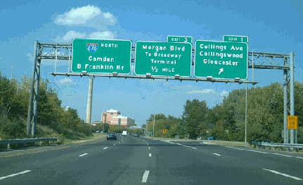
The first section of I-676, from the Walt Whitman Bridge approach (I-76) north to EXIT 3 (Morgan Boulevard), was opened to traffic in 1957 with the completion of the Walt Whitman Bridge. Further north, a second short section of I-676 from the Benjamin Franklin Bridge approach south to EXIT 5 (Camden CR 537-Federal Street) opened in 1972. The final section of I-676 in New Jersey opened in 1980, completing the "missing link" between EXIT 3 and EXIT 5, and ending more than three decades of planning and construction of the North-South Freeway. |
||
|
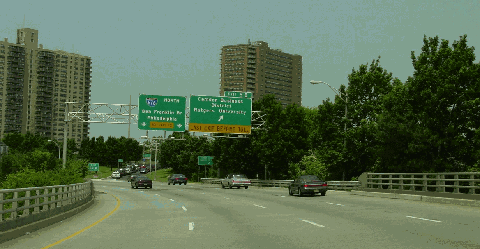
This 2002 photo shows the northbound I-676 at EXIT 5B (Camden Waterfront) in downtown Camden, approaching the Benjamin Franklin Bridge. (Photo by Jim K. Georges.) |
||

|
SOURCES: Regional Plan of the Philadelphia Tri-State District, Regional Planning Federation (1932); "New Roads with New Numbers Will Parallel Old U.S. Routes" by George Cable Wright, The New York Times (9/19/1958); "Location Studies for North-South Freeway: Interstate 76," New Jersey Highway Department (1965); New Jersey Highway Facts, New Jersey Department of Transportation (1967); 1985 Regional Transportation Plan, Delaware Valley Regional Planning Commission (1969); "Interstate 676: Administrative Action Final Environmental Impact Statement and Section 4(f) Statement," Federal Highway Administration and New Jersey Department of Transportation (1976); Chris Blaney; Jeff Kitsko; Scott Kozel; Raymond C. Martin; Christopher G. Mason; Dan Moraseski; Sandy Smith; Stephen Summers; Jeff Taylor; Rush Wickes. |
||
|
INTERSTATE 676 LINKS: |
||
|
INTERSTATE 676 CURRENT CONDITIONS: |
||

|
OFF-SITE EXIT LISTINGS: |
||
|
VIEW OR SUBMIT YOUR RATING TO RATETHEROADS.COM: |
||
|
|
||
|
Back to The Roads of Metro Philadelphia home page. |
||
|
Site contents © by Eastern Roads. This is not an official site run by a government agency. Recommendations provided on this site are strictly those of the author and contributors, not of any government or corporate entity. |
||