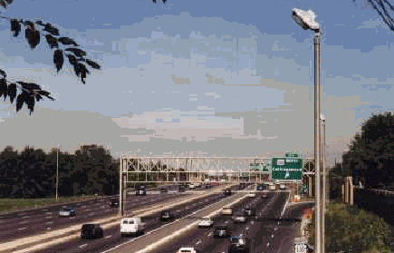
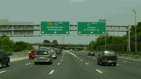
This 1999 photo shows the westbound I-76 (North-South Freeway) at EXIT 1D (US 130) in Gloucester City. (Photo by Steve Anderson.)
PLANNED AS A PARKWAY: In 1932, the Regional Planning Federation (the predecessor agency to the Delaware Valley Regional Planning Commission) proposed a parkway system around the Philadelphia area similar to that constructed by Robert Moses. Like the Moses parkways in New York, the four-lane parkways were to feature controlled access, stone-arch bridges, timber lightposts and natural vegetation.
The plan proposed a parkway extending from the Benjamin Franklin Bridge approach in Camden southeast to Atlantic City. The Camden-Atlantic City parkway was to have been constructed along the North-South Freeway (I-76 / I-676 / NJ 42) and Atlantic City Expressway alignment. However, without a forceful "power broker" such as Moses to direct public works projects in the Delaware Valley, the route remained a dotted line through South Jersey until after World War II.
A NEW NORTH-SOUTH ROUTE FOR CAMDEN: In the late 1940's, the New Jersey State Highway Department proposed the North-South Freeway, a link that was to connect the eastern approach of the Benjamin Franklin Bridge with downtown Camden and other points in southern New Jersey. By the 1950's, The Federal Bureau of Public Roads (BPR) selected a route along the current I-76 and I-676 alignments. However, fiscal difficulties - the state was to pay for half the cost of the freeway - prevented further progress.
Right-of-way acquisition began in the early 1950's, and construction of the North-South Freeway soon followed. In 1956, a section of the proposed NJ 42 Freeway from the Ben Franklin Bridge south to Gloucester City became eligible for 90 percent Federal funding under the National System of Interstate and Defense Highways Act. Over the years, the "urban connecting route" had different designations:
June 1956-June 1958: "FAI Corridor 109"
June 1958-October 1958: I-280; from the Walt Whitman Bridge to I-295. Pennsylvania officials proposed this designation.
October 1958-November 1958: I-395 and I-380; New Jersey officials suggested these designations. The preliminary I-395 designation included the Walt Whitman Bridge and its approaches. The preliminary I-380 designation began southeast of the Walt Whitman Bridge approach (where I-395 ended), and was to continue north to the Benjamin Franklin Bridge.
November 1958-early 1964: I-680 and I-80S. This was the final designation given by the American Association of State Highway Officials (AASHO). The I-680 designation included the Walt Whitman Bridge and its approaches. The I-80S designation began southeast of the Walt Whitman Bridge approach (where I-680 ended), and was to continue north to the Benjamin Franklin Bridge.
1964-1973: I-676 and I-76; approved by AASHO.
1973-present: I-76; the I-76 and I-676 designations through Philadelphia and Camden changed in 1973.
The 3.1 miles of I-76 in New Jersey opened to traffic on May 16, 1957, the same day that the nearby Walt Whitman Bridge was formally opened. The expressway was widened to its current 12-lane configuration in 1960.
In its 1967 report New Jersey Highway Facts, the New Jersey Department of Transportation (NJDOT) described the purpose of the combined I-76 / I-676 through the Philadelphia-Camden metropolitan area as follows:
Interstate 76 and Interstate 676 will provide a direct express link from I-295 in Camden County to the Walt Whitman Bridge, the Benjamin Franklin Bridge, and the cities of Camden and Philadelphia.
The completion of I-676 in 1980, in conjunction with the existing section of I-76, provided South Jersey motorists better access to the Camden waterfront.
This 2002 photo shows the westbound I-76 at EXIT 2 (I-676) in Gloucester City. (Photo by Jim K. Georges.)
DESIGN SPECIFICATIONS: This section of the North-South Freeway, which was planned with a design speed of 60 MPH (the actual speed limit on this section is 55 MPH), was designed with access to the Walt Whitman and Benjamin Franklin bridges in mind. Between the I-295 / NJ 42 interchange in Bellmawr and the I-676 junction in Gloucester City, I-76 has ten 12-foot-wide lanes that carry approximately 145,000 vehicles per day (AADT). Interstate-standard shoulders, acceleration lanes and deceleration lanes are also provided.
Between I-295 and I-676, the westbound carriageways of I-76 consist of two express lanes and three local lanes. A barrier between the local and express lanes prevents interference of merging traffic from I-295 and US 130. An additional westbound local lane is provided just south of the I-76 / I-676 interchange. Along the eastbound I-76, there are no longer separate lanes for local and express traffic. Instead, there is a single five-lane carriageway.
More information on the I-76 lane configuration from misc.transport.road and phillyroads.com contributor Jeff Taylor as follows:
In the late 1990's, as part of the NJ 42 Freeway widening project, the NJDOT decided to remove the I-76 eastbound local-express barrier for safety reasons. Prior to the removal of the barriers, congestion usually formed when eastbound traffic leaving the Walt Whitman Bridge had to choose between either two express lanes or one local lane. The I-76 westbound barrier remained, but was shortened back to the US 130 area.
Traffic engineers realized that the express lanes were still being underutilized, and the local lanes were exceeding capacity. The NJDOT then decided to allow traffic bound for I-676 northbound to use the I-76 westbound express lanes. Motorists would still have about three-quarters of a mile to move over two lanes for I-676 northbound.
UNTANGLING THE NJ 42 / I-76 / I-295 MESS: As early as 1985, the NJDOT began studies of rebuilding the interchange between I-76, I-295, and the NJ 42 Freeway in the Borough of Bellmawr. The present interchange, which carries approximately 200,000 vehicles per day (AADT) between the three roadways, does not permit a direct connection for I-295 through traffic. These motorists must negotiate 35 MPH hairpin curves (nicknamed the "Al-Jo" curves after a tavern formerly located on the site of the interchange) to stay on I-295. Motorists traveling between I-295 and I-76 / NJ 42 Freeway have their own problems of weaving, tight curves and missing movements (especially between points west and south). These substandard conditions have been the cause of hundreds of accidents each year since the interchange was completed in 1961.
The NJDOT announced preliminary plans to rebuild this interchange in 2000. The rebuilt interchange would have one or more elevated highways designed to straighten out the current snarl at the interchange. Through-traffic movements would be realigned and redesigned for a maximum design speed of 60 MPH, and new and rebuilt ramps would be constructed. Engineers selected 16 different design alternatives for the rebuilt interchange. A 2004 draft environmental impact statement narrowed the number of alternatives down to five.
In 2007, the NJDOT selected "alternative D" for the interchange, which features a six-lane elevated roadway to carry I-295 over I-76 / NJ 42 at a posted speed of 55 MPH. Existing ramps will be redesigned to current safety standards, and the "missing moves" ramps (northbound I-295 to southbound NJ 42, and northbound NJ 42 to southbound I-295) will be built south of the existing interchange. The rebuilt interchange would resemble a "double-directional-T" interchange.
Final engineering and design work is expected to continue through 2009, with construction slated to begin in 2011. The NJDOT expects the $450 million project to be completed by 2015.
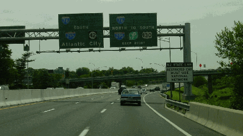
This 2002 photo shows the eastbound I-76 approaching the junction with I-676 (North-South Freeway) in Gloucester City. (Photo by Jim K. Georges.)
The I-76 designation should be extended east along the NJ 42 Freeway and the Atlantic City Expressway to Atlantic City. Exit numbering on the extended I-76 thus would begin at the Walt Whitman Bridge and continue southeast to Atlantic City.
SOURCES: Regional Plan of the Philadelphia Tri-State District, Regional Planning Federation (1932); "Philadelphia's New Shore Route" by William J. Weart, The New York Times (4/21/1957); "Bridge Is Opened at Philadelphia" by William J. Weart, The New York Times (5/16/1957); "New Roads with New Numbers Will Parallel Old U.S. Routes" by George Cable Wright, The New York Times (9/19/1958); "Location Studies for North-South Freeway: Interstate 76," New Jersey Highway Department (1965); New Jersey Highway Facts, New Jersey Department of Transportation (1967); 1985 Regional Transportation Plan, Delaware Valley Regional Planning Commission (1969); "Relief Proposed for Traffic Headache" by Jason Laughlin, The Courier-Post (4/21/2000); "New Jersey Promises To Untangle a Traffic Knot" by Jennifer Moroz, The Philadelphia Inquirer (11/24/2004); Chris Blaney; Jeff Kitsko; Michael G. Koerner; Scott Kozel; Raymond C. Martin; Christopher G. Mason; Dan Moraseski; Brian Polidoro; Sandy Smith; Stephen Summers; Jeff Taylor; Rush Wickes.
I-76 shield by Ralph Herman. Lightposts by Millerbernd Manufacturing Company.


